Trinidad geodata
Trinidad (El Beni) is a seat of a first-order administrative division; located in Bolivia in America/La_Paz (GMT-4) time zone. With population of 84,259 people, there are 10 cities with bigger population in this country. Compared to other cities in Bolivia, 93.8% of cities are located further ↓South; 59% of cities are located further ←West and 95.7% of cities have higher elevation than Trinidad. Note1


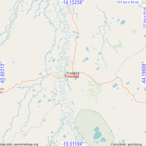
Trinidad GPS coordinates[2]
14° 49' 59.988" South, 64° 54' 0" West
| Map corner | latitude | longitude |
|---|---|---|
| Upper-left | -14.15258°, | -65.60313° |
| Center: | -14.83333°, | -64.9° |
| Lower-right: | -15.51194°, | -64.19688° |
| Map W x H: | 151.1×151.1 km | = 93.9×93.9mi |
| max Lat: | -9.71828° ⇑6.2% North |
| Trinidad: | -14.83333° |
| min Lat: | ⇓93.8% South -22.73206° |
| min Long | Trinidad | max Long |
| -69.14843° | -64.9° | -57.76667° |
| W 59%⇐ | ⇒41% E |
Elevation
Elevation of Trinidad is 159 m = 522 ft, and this is 1852.3 m = 6077 ft below average elevation for this country.
| Max E: |
4732 m = 15525 ft | 95.7% |
| Avg. | 2011.3 m = 6599 ft | |
| Trinidad | 159 m = 522 ft | |
Min E: |
92 m = 302 ft | 4.3% |
See also: Trinidad elevation on elevation.city.
Geographical zone
Trinidad is located in South Torrid zone (between Equator and Tropic of Capricorn). Distance of this Southern Tropic circle is 956.6 km =594.4 mi to South.| Distance of | km | miles | from Trinidad |
|---|---|---|---|
| Equator | 1649.3 | 1024.8 | to North |
| Tropic Capricorn | 956.6 | 594.4 | to South |
| Antarctic Circle | 5751.9 | 3574.1 | to South |
| South Pole | 8357.8 | 5193.3 | to South |


Nearby cities:
15 places around Trinidad: (largest is in red/bold)
• Ascención de Guarayos
218.1 km =135.5 mi,  122°
122°
• Ascensión
217.4 km =135.1 mi, 116°
• Chimoré
241.8 km =150.2 mi,  186°
186°
• Colomi
298.3 km =185.4 mi,  200°
200°
• Reyes
268.9 km =167.1 mi,  282°
282°
• Rurrenabaque
286 km =177.7 mi, 278°
• Sacaba
310 km =192.6 mi, 203°
• San Borja
198.8 km =123.5 mi,  269°
269°
• San Borja
209.6 km =130.2 mi, 270°
• San Ramón
173.5 km =107.8 mi,  6°
6°
• Santa Ana de Yacuma
133.8 km =83.1 mi,  334°
334°
• Santa Rosa
226 km =140.4 mi,  289°
289°
• Santa Rosa del Sara
288.9 km =179.5 mi,  151°
151°
• Urubichá
218.7 km =135.9 mi,  106°
106°
• Villa Yapacaní
307.3 km =190.9 mi,  158°
158°
Sources, notices
• [Note1] Compared only with cities in Bolivia existing in our database
• [Src1] Map data: © OpenStreetMap contributors (CC-BY-SA)
• [Src2] Other city data from geonames.org with taken over terms of usage.
• [Src3] Geographical zone / Annual Mean Temperature by Robert A. Rohde @ Wikipedia
