São Félix do Xingu geodata
São Félix do Xingu (Pará) is a populated place; located in Brazil in America/Belem (GMT-3) time zone. With population of 16,477 people, there are 1123 cities with bigger population in this country. Compared to other cities in Brazil, 82.2% of cities are located further ↓South; 87.8% of cities are located further →East and 61.1% of cities have higher elevation than São Félix do Xingu. Note1


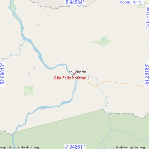
São Félix do Xingu GPS coordinates[2]
6° 38' 40.992" South, 51° 59' 42" West
| Map corner | latitude | longitude |
|---|---|---|
| Upper-left | -5.94584°, | -52.69813° |
| Center: | -6.64472°, | -51.995° |
| Lower-right: | -7.34261°, | -51.29188° |
| Map W x H: | 155.3×155.3 km | = 96.5×96.5mi |
| max Lat: | 2.81972° ⇑17.8% North |
| São Félix do Xingu: | -6.64472° |
| min Lat: | ⇓82.2% South -33.69111° |
| min Long | São Félix do | max Long |
| -72.89583° | -51.995° | -32.41083° |
| W 12.2%⇐ | ⇒87.8% E |
Elevation
Elevation of São Félix do Xingu is 199 m = 653 ft, and this is 181.9 m = 597 ft below average elevation for this country.
| Max E: |
1603 m = 5259 ft | 61.1% |
| Avg. | 380.9 m = 1250 ft | |
| São Félix do Xingu | 199 m = 653 ft | |
Min E: |
0 m = 0 ft | 38.9% |
See also: Brazil elevation on elevation.city.
Geographical zone
São Félix do Xingu is located in South Torrid zone (between Equator and Tropic of Capricorn). Distance of Equator is 738.8 km =459.1 mi to North.| Distance of | km | miles | from São Félix do Xingu |
|---|---|---|---|
| Equator | 738.8 | 459.1 | to North |
| Tropic Capricorn | 1867.1 | 1160.2 | to South |
| Antarctic Circle | 6662.4 | 4139.8 | to South |
| South Pole | 9268.2 | 5759 | to South |


Nearby cities:
12 places around São Félix do Xingu: (largest is in red/bold)
• Altamira
383.4 km =238.2 mi,  356°
356°
• Araguaína
422.5 km =262.5 mi,  98°
98°
• Conceição do Araguaia
350.3 km =217.7 mi,  120°
120°
• Itupiranga
339.5 km =211 mi,  60°
60°
• Marabá
346.3 km =215.2 mi,  66°
66°
• Ourilândia do Norte
101.4 km =63 mi, 96°
• Parauapebas
240 km =149.1 mi, 74°
• Redenção
265.6 km =165 mi,  125°
125°
• São Geraldo do Araguaia
381 km =236.7 mi,  85°
85°
• Tucumã
92.8 km =57.7 mi, 97°
• Tucuruí
410.1 km =254.8 mi,  38°
38°
• Xinguara
232 km =144.2 mi, 102°
Sources, notices
• [Note1] Compared only with cities in Brazil existing in our database
• [Src1] Map data: © OpenStreetMap contributors (CC-BY-SA)
• [Src2] Other city data from geonames.org with taken over terms of usage.
• [Src3] Geographical zone / Annual Mean Temperature by Robert A. Rohde @ Wikipedia
