Xinguara geodata
Xinguara (Pará) is a populated place; located in Brazil in America/Belem (GMT-3) time zone. With population of 43,530 people, there are 490 cities with bigger population in this country. Compared to other cities in Brazil, 80% of cities are located further ↓South; 77.8% of cities are located further →East and 56.3% of cities have higher elevation than Xinguara. Note1


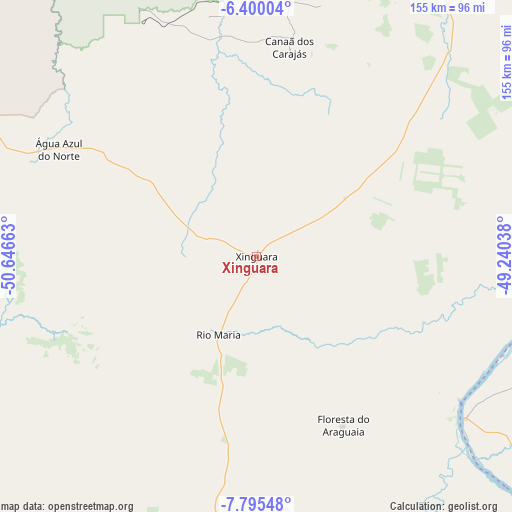
Xinguara GPS coordinates[2]
7° 5' 53.844" South, 49° 56' 36.6" West
| Map corner | latitude | longitude |
|---|---|---|
| Upper-left | -6.40004°, | -50.64663° |
| Center: | -7.09829°, | -49.9435° |
| Lower-right: | -7.79548°, | -49.24038° |
| Map W x H: | 155.2×155.2 km | = 96.4×96.4mi |
| max Lat: | 2.81972° ⇑20% North |
| Xinguara: | -7.09829° |
| min Lat: | ⇓80% South -33.69111° |
| min Long | Xinguara | max Long |
| -72.89583° | -49.9435° | -32.41083° |
| W 22.2%⇐ | ⇒77.8% E |
Elevation
Elevation of Xinguara is 252 m = 827 ft, and this is 128.9 m = 423 ft below average elevation for this country.
| Max E: |
1603 m = 5259 ft | 56.3% |
| Avg. | 380.9 m = 1250 ft | |
| Xinguara | 252 m = 827 ft | |
Min E: |
0 m = 0 ft | 43.7% |
See also: Xinguara elevation on elevation.city.
Geographical zone
Xinguara is located in South Torrid zone (between Equator and Tropic of Capricorn). Distance of Equator is 789.3 km =490.4 mi to North.| Distance of | km | miles | from Xinguara |
|---|---|---|---|
| Equator | 789.3 | 490.4 | to North |
| Tropic Capricorn | 1816.7 | 1128.8 | to South |
| Antarctic Circle | 6611.9 | 4108.4 | to South |
| South Pole | 9217.8 | 5727.7 | to South |


Nearby cities:
15 places around Xinguara: (largest is in red/bold)
• Araguaína
191.8 km =119.2 mi,  93°
93°
• Carolina
275 km =170.9 mi,  95°
95°
• Conceição do Araguaia
149.4 km =92.8 mi,  150°
150°
• Imperatriz
322.4 km =200.3 mi,  57°
57°
• Itupiranga
228.7 km =142.1 mi,  17°
17°
• Marabá
210.9 km =131 mi,  25°
25°
• Miracema do Tocantins
323.3 km =200.9 mi, 148°
• Ourilândia do Norte
131.5 km =81.7 mi,  286°
286°
• Parauapebas
114.7 km =71.3 mi,  2°
2°
• Porto Franco
293.4 km =182.3 mi,  73°
73°
• Redenção
103.9 km =64.6 mi,  185°
185°
• Santa Luzia
306.6 km =190.5 mi, 101°
• São Félix do Xingu
232 km =144.2 mi,  282°
282°
• São Geraldo do Araguaia
171.8 km =106.8 mi, 63°
• Tucumã
139.9 km =86.9 mi, 286°
Sources, notices
• [Note1] Compared only with cities in Brazil existing in our database
• [Src1] Map data: © OpenStreetMap contributors (CC-BY-SA)
• [Src2] Other city data from geonames.org with taken over terms of usage.
• [Src3] Geographical zone / Annual Mean Temperature by Robert A. Rohde @ Wikipedia
