São Geraldo do Araguaia geodata
São Geraldo do Araguaia (Pará) is a populated place; located in Brazil in America/Araguaina (GMT-3) time zone. With population of 12,925 people, there are 1376 cities with bigger population in this country. Compared to other cities in Brazil, 83.5% of cities are located further ↓South; 68.1% of cities are located further →East and 69.2% of cities have higher elevation than São Geraldo do Araguaia. Note1
Current local time in São Geraldo do Araguaia:
08:14 PM, TuesdayDifference from your time zone: hours


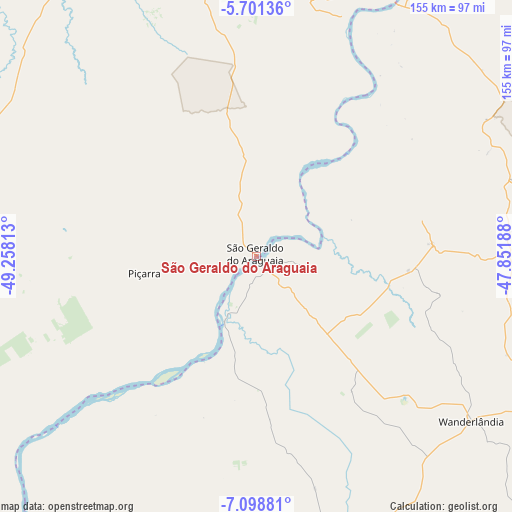
São Geraldo do Araguaia GPS coordinates[2]
6° 24' 2.016" South, 48° 33' 18" West
| Map corner | latitude | longitude |
|---|---|---|
| Upper-left | -5.70136°, | -49.25813° |
| Center: | -6.40056°, | -48.555° |
| Lower-right: | -7.09881°, | -47.85188° |
| Map W x H: | 155.4×155.4 km | = 96.6×96.6mi |
| max Lat: | 2.81972° ⇑16.5% North |
| São Geraldo do Araguaia: | -6.40056° |
| min Lat: | ⇓83.5% South -33.69111° |
| min Long | São Geraldo do | max Long |
| -72.89583° | -48.555° | -32.41083° |
| W 31.9%⇐ | ⇒68.1% E |
Elevation
Elevation of São Geraldo do Araguaia is 131 m = 430 ft, and this is 249.9 m = 820 ft below average elevation for this country.
| Max E: |
1603 m = 5259 ft | 69.2% |
| Avg. | 380.9 m = 1250 ft | |
| São Geraldo do Araguaia | 131 m = 430 ft | |
Min E: |
0 m = 0 ft | 30.8% |
See also: Brazil elevation on elevation.city.
Geographical zone
São Geraldo do Araguaia is located in South Torrid zone (between Equator and Tropic of Capricorn). Distance of Equator is 711.7 km =442.2 mi to North.| Distance of | km | miles | from São Geraldo do Araguaia |
|---|---|---|---|
| Equator | 711.7 | 442.2 | to North |
| Tropic Capricorn | 1894.2 | 1177 | to South |
| Antarctic Circle | 6689.5 | 4156.7 | to South |
| South Pole | 9295.4 | 5775.9 | to South |


Nearby cities:
15 places around São Geraldo do Araguaia: (largest is in red/bold)
• Amarante do Maranhão
220.9 km =137.3 mi,  65°
65°
• Araguaína
95.9 km =59.6 mi,  156°
156°
• Bom Jardim
238.8 km =148.4 mi,  106°
106°
• Carolina
159.3 km =99 mi,  130°
130°
• Conceição do Araguaia
221.7 km =137.8 mi,  200°
200°
• Imperatriz
152.6 km =94.8 mi,  50°
50°
• Itupiranga
164.6 km =102.3 mi,  328°
328°
• Marabá
130.1 km =80.8 mi, 330°
• Montes Altos
176.2 km =109.5 mi, 69°
• Parauapebas
153.4 km =95.3 mi,  283°
283°
• Porto Franco
127.9 km =79.5 mi,  86°
86°
• Redenção
243.5 km =151.3 mi,  221°
221°
• Riachão
239.1 km =148.6 mi,  116°
116°
• Santa Luzia
202.1 km =125.6 mi, 133°
• Xinguara
171.8 km =106.8 mi,  243°
243°
Sources, notices
• [Note1] Compared only with cities in Brazil existing in our database
• [Src1] Map data: © OpenStreetMap contributors (CC-BY-SA)
• [Src2] Other city data from geonames.org with taken over terms of usage.
• [Src3] Geographical zone / Annual Mean Temperature by Robert A. Rohde @ Wikipedia
