Marabá geodata
Marabá (Pará) is a populated place; located in Brazil in America/Belem (GMT-3) time zone. With population of 145,860 people, there are 158 cities with bigger population in this country. Compared to other cities in Brazil, 87.6% of cities are located further ↓South; 72.5% of cities are located further →East and 73% of cities have higher elevation than Marabá. Note1


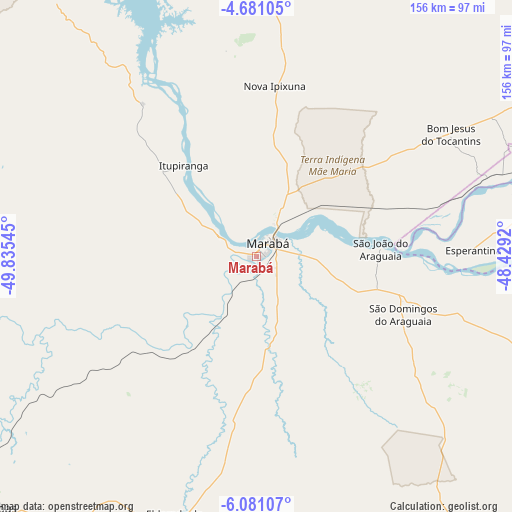
Marabá GPS coordinates[2]
5° 22' 53.256" South, 49° 7' 56.352" West
| Map corner | latitude | longitude |
|---|---|---|
| Upper-left | -4.68105°, | -49.83545° |
| Center: | -5.38146°, | -49.13232° |
| Lower-right: | -6.08107°, | -48.4292° |
| Map W x H: | 155.7×155.7 km | = 96.7×96.7mi |
| max Lat: | 2.81972° ⇑12.4% North |
| Marabá: | -5.38146° |
| min Lat: | ⇓87.6% South -33.69111° |
| min Long | Marabá | max Long |
| -72.89583° | -49.13232° | -32.41083° |
| W 27.5%⇐ | ⇒72.5% E |
Elevation
Elevation of Marabá is 95 m = 312 ft, and this is 285.9 m = 938 ft below average elevation for this country.
| Max E: |
1603 m = 5259 ft | 73% |
| Avg. | 380.9 m = 1250 ft | |
| Marabá | 95 m = 312 ft | |
Min E: |
0 m = 0 ft | 27% |
See also: Marabá elevation on elevation.city.
Geographical zone
Marabá is located in South Torrid zone (between Equator and Tropic of Capricorn). Distance of Equator is 598.4 km =371.8 mi to North.| Distance of | km | miles | from Marabá |
|---|---|---|---|
| Equator | 598.4 | 371.8 | to North |
| Tropic Capricorn | 2007.6 | 1247.5 | to South |
| Antarctic Circle | 6802.8 | 4227.1 | to South |
| South Pole | 9408.7 | 5846.3 | to South |


Nearby cities:
15 places around Marabá: (largest is in red/bold)
• Amarante do Maranhão
265.3 km =164.8 mi,  94°
94°
• Araguaína
225.7 km =140.2 mi,  153°
153°
• Baião
294.2 km =182.8 mi,  348°
348°
• Carolina
285.1 km =177.2 mi,  139°
139°
• Imperatriz
182.3 km =113.3 mi,  95°
95°
• Itupiranga
34.9 km =21.7 mi,  321°
321°
• Montes Altos
234 km =145.4 mi, 102°
• Ourilândia do Norte
264.3 km =164.2 mi,  234°
234°
• Parauapebas
114.3 km =71 mi, 228°
• Porto Franco
219.2 km =136.2 mi,  119°
119°
• Redenção
310.6 km =193 mi,  198°
198°
• São Geraldo do Araguaia
130.1 km =80.8 mi, 150°
• Tucumã
270.9 km =168.3 mi,  235°
235°
• Tucuruí
189.6 km =117.8 mi,  341°
341°
• Xinguara
210.9 km =131 mi,  205°
205°
Sources, notices
• [Note1] Compared only with cities in Brazil existing in our database
• [Src1] Map data: © OpenStreetMap contributors (CC-BY-SA)
• [Src2] Other city data from geonames.org with taken over terms of usage.
• [Src3] Geographical zone / Annual Mean Temperature by Robert A. Rohde @ Wikipedia
