Gurupá geodata
Gurupá (Pará) is a populated place; located in Brazil in America/Belem (GMT-3) time zone. With population of 6,461 people, there are 1858 cities with bigger population in this country. Compared to other cities in Brazil, 98.6% of cities are located further ↓South; 86.1% of cities are located further →East and 99.3% of cities have higher elevation than Gurupá. Note1


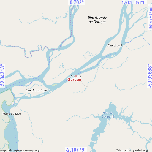
Gurupá GPS coordinates[2]
1° 24' 18" South, 51° 38' 24" West
| Map corner | latitude | longitude |
|---|---|---|
| Upper-left | -0.702°, | -52.34313° |
| Center: | -1.405°, | -51.64° |
| Lower-right: | -2.10779°, | -50.93688° |
| Map W x H: | 156.3×156.3 km | = 97.1×97.1mi |
| max Lat: | 2.81972° ⇑1.4% North |
| Gurupá: | -1.405° |
| min Lat: | ⇓98.6% South -33.69111° |
| min Long | Gurupá | max Long |
| -72.89583° | -51.64° | -32.41083° |
| W 13.9%⇐ | ⇒86.1% E |
Elevation
Elevation of Gurupá is 4 m = 13 ft, and this is 376.9 m = 1237 ft below average elevation for this country.
| Max E: |
1603 m = 5259 ft | 99.3% |
| Avg. | 380.9 m = 1250 ft | |
| Gurupá | 4 m = 13 ft | |
Min E: |
0 m = 0 ft | 0.7% |
See also: Brazil elevation on elevation.city.
Geographical zone
Gurupá is located in South Torrid zone (between Equator and Tropic of Capricorn). Distance of Equator is 156.2 km =97.1 mi to North.| Distance of | km | miles | from Gurupá |
|---|---|---|---|
| Equator | 156.2 | 97.1 | to North |
| Tropic Capricorn | 2449.7 | 1522.2 | to South |
| Antarctic Circle | 7245 | 4501.8 | to South |
| South Pole | 9850.8 | 6121 | to South |


Nearby cities:
15 places around Gurupá: (largest is in red/bold)
• Afuá
196.7 km =122.2 mi,  45°
45°
• Almeirim
105.5 km =65.6 mi,  262°
262°
• Altamira
209.6 km =130.2 mi,  197°
197°
• Breves
132.5 km =82.3 mi,  103°
103°
• Cametá
255.9 km =159 mi,  111°
111°
• Limoeiro do Ajuru
257 km =159.7 mi, 102°
• Macapá
172.7 km =107.3 mi,  21°
21°
• Mazagão
148.6 km =92.3 mi, 15°
• Oeiras do Pará
209.3 km =130.1 mi, 108°
• Portel
108.5 km =67.4 mi,  122°
122°
• Porto de Moz
76.7 km =47.7 mi,  240°
240°
• Prainha
209.2 km =130 mi, 257°
• Santana
158.2 km =98.3 mi, 18°
• Senador José Porfírio
136.4 km =84.8 mi,  194°
194°
• Tucumã
222.9 km =138.5 mi, 52°
Sources, notices
• [Note1] Compared only with cities in Brazil existing in our database
• [Src1] Map data: © OpenStreetMap contributors (CC-BY-SA)
• [Src2] Other city data from geonames.org with taken over terms of usage.
• [Src3] Geographical zone / Annual Mean Temperature by Robert A. Rohde @ Wikipedia
