Santana geodata
Santana (Amapá) is a populated place; located in Brazil in America/Belem (GMT-3) time zone. With population of 83,927 people, there are 275 cities with bigger population in this country. Compared to other cities in Brazil, 99.9% of cities are located further ↓South; 83.9% of cities are located further →East and 100% of cities have higher elevation than Santana. Note1


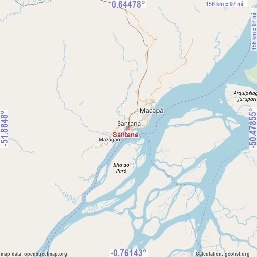
Santana GPS coordinates[2]
0° 3' 29.988" South, 51° 10' 54.012" West
| Map corner | latitude | longitude |
|---|---|---|
| Upper-left | 0.64478°, | -51.8848° |
| Center: | -0.05833°, | -51.18167° |
| Lower-right: | -0.76143°, | -50.47855° |
| Map W x H: | 156.4×156.4 km | = 97.2×97.2mi |
| max Lat: | 2.81972° ⇑0.1% North |
| Santana: | -0.05833° |
| min Lat: | ⇓99.9% South -33.69111° |
| min Long | Santana | max Long |
| -72.89583° | -51.18167° | -32.41083° |
| W 16.1%⇐ | ⇒83.9% E |
Elevation
Elevation of Santana is 0 m = 0 ft, and this is 380.9 m = 1250 ft below average elevation for this country.
| Max E: |
1603 m = 5259 ft | 100% |
| Avg. | 380.9 m = 1250 ft | |
| Santana | 0 m = 0 ft | |
Min E: |
0 m = 0 ft | 0% |
See also: Santana elevation on elevation.city.
Geographical zone
Santana is located in South Torrid zone (between Equator and Tropic of Capricorn). Distance of Equator is 6.5 km =4 mi to North.| Distance of | km | miles | from Santana |
|---|---|---|---|
| Equator | 6.5 | 4 | to North |
| Tropic Capricorn | 2599.4 | 1615.2 | to South |
| Antarctic Circle | 7394.7 | 4594.9 | to South |
| South Pole | 10000.6 | 6214.1 | to South |


Nearby cities:
15 places around Santana: (largest is in red/bold)
• Afuá
89.1 km =55.4 mi,  97°
97°
• Almeirim
225.3 km =140 mi,  223°
223°
• Breves
196.7 km =122.2 mi,  156°
156°
• Cametá
306.9 km =190.7 mi,  142°
142°
• Gurupá
158.2 km =98.3 mi,  198°
198°
• Limoeiro do Ajuru
286 km =177.7 mi, 135°
• Macapá
16.8 km =10.4 mi,  49°
49°
• Mazagão
13.5 km =8.4 mi,  242°
242°
• Muaná
272.8 km =169.5 mi,  126°
126°
• Oeiras do Pará
261.8 km =162.7 mi,  145°
145°
• Portel
212.5 km =132 mi,  169°
169°
• Porto de Moz
221.6 km =137.7 mi,  212°
212°
• Senador José Porfírio
294.4 km =182.9 mi, 196°
• Soure
304.5 km =189.2 mi, 103°
• Tucumã
126.6 km =78.7 mi, 96°
Sources, notices
• [Note1] Compared only with cities in Brazil existing in our database
• [Src1] Map data: © OpenStreetMap contributors (CC-BY-SA)
• [Src2] Other city data from geonames.org with taken over terms of usage.
• [Src3] Geographical zone / Annual Mean Temperature by Robert A. Rohde @ Wikipedia
