Macapá geodata
Macapá (Amapá) is a seat of a first-order administrative division; located in Brazil in America/Belem (GMT-3) time zone. With population of 338,936 people, there are 58 cities with bigger population in this country. Compared to other cities in Brazil, 100% of cities are located further ↓South; 82.7% of cities are located further →East and 90.4% of cities have higher elevation than Macapá. Note1


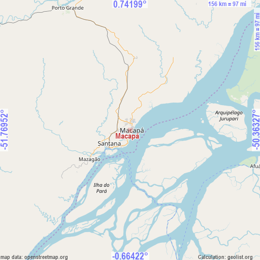
Macapá GPS coordinates[2]
0° 2' 20.004" North, 51° 3' 59.004" West
| Map corner | latitude | longitude |
|---|---|---|
| Upper-left | 0.74199°, | -51.76952° |
| Center: | 0.03889°, | -51.06639° |
| Lower-right: | -0.66422°, | -50.36327° |
| Map W x H: | 156.4×156.4 km | = 97.2×97.2mi |
| max Lat: | 2.81972° ⇑0% North |
| Macapá: | 0.03889° |
| min Lat: | ⇓100% South -33.69111° |
| min Long | Macapá | max Long |
| -72.89583° | -51.06639° | -32.41083° |
| W 17.3%⇐ | ⇒82.7% E |
Elevation
Elevation of Macapá is 17 m = 56 ft, and this is 363.9 m = 1194 ft below average elevation for this country.
| Max E: |
1603 m = 5259 ft | 90.4% |
| Avg. | 380.9 m = 1250 ft | |
| Macapá | 17 m = 56 ft | |
Min E: |
0 m = 0 ft | 9.6% |
See also: Macapá elevation on elevation.city.
Geographical zone
Macapá is located in North Torrid zone (between Equator and Tropic of Cancer). Distance of Equator is 4.3 km =2.7 mi to South.| Distance of | km | miles | from Macapá |
|---|---|---|---|
| North Pole | 10002.7 | 6215.4 | to North |
| Arctic Circle | 7396.8 | 4596.2 | to North |
| Tropic Cancer | 2601.6 | 1616.6 | to North |
| Equator | 4.3 | 2.7 | to South |


Nearby cities:
15 places around Macapá: (largest is in red/bold)
• Afuá
78.6 km =48.8 mi,  106°
106°
• Almeirim
242 km =150.4 mi,  224°
224°
• Breves
202.2 km =125.6 mi,  161°
161°
• Cametá
308.1 km =191.4 mi,  145°
145°
• Gurupá
172.7 km =107.3 mi,  201°
201°
• Limoeiro do Ajuru
285.3 km =177.3 mi,  138°
138°
• Mazagão
30.1 km =18.7 mi,  235°
235°
• Muaná
269.5 km =167.5 mi,  130°
130°
• Oeiras do Pará
264 km =164 mi, 149°
• Portel
221.2 km =137.4 mi,  172°
172°
• Porto de Moz
237.6 km =147.6 mi,  213°
213°
• Santana
16.8 km =10.4 mi,  229°
229°
• Senador José Porfírio
308.6 km =191.8 mi, 198°
• Soure
295 km =183.3 mi, 106°
• Tucumã
115.7 km =71.9 mi,  102°
102°
Sources, notices
• [Note1] Compared only with cities in Brazil existing in our database
• [Src1] Map data: © OpenStreetMap contributors (CC-BY-SA)
• [Src2] Other city data from geonames.org with taken over terms of usage.
• [Src3] Geographical zone / Annual Mean Temperature by Robert A. Rohde @ Wikipedia
