Tucumã geodata
Tucumã (Pará) is a populated place; located in Brazil in America/Belem (GMT-3) time zone. With population of 15,030 people, there are 1212 cities with bigger population in this country. Compared to other cities in Brazil, 99.7% of cities are located further ↓South; 78.5% of cities are located further →East and 92.4% of cities have higher elevation than Tucumã. Note1


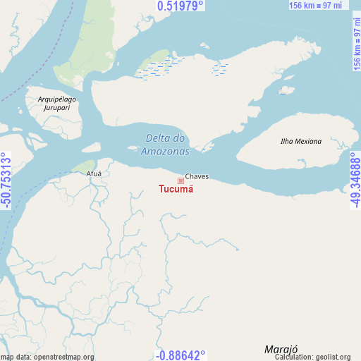
Tucumã GPS coordinates[2]
0° 10' 59.988" South, 50° 3' 0" West
| Map corner | latitude | longitude |
|---|---|---|
| Upper-left | 0.51979°, | -50.75313° |
| Center: | -0.18333°, | -50.05° |
| Lower-right: | -0.88642°, | -49.34688° |
| Map W x H: | 156.4×156.4 km | = 97.2×97.2mi |
| max Lat: | 2.81972° ⇑0.3% North |
| Tucumã: | -0.18333° |
| min Lat: | ⇓99.7% South -33.69111° |
| min Long | Tucumã | max Long |
| -72.89583° | -50.05° | -32.41083° |
| W 21.5%⇐ | ⇒78.5% E |
Elevation
Elevation of Tucumã is 13 m = 43 ft, and this is 367.9 m = 1207 ft below average elevation for this country.
| Max E: |
1603 m = 5259 ft | 92.4% |
| Avg. | 380.9 m = 1250 ft | |
| Tucumã | 13 m = 43 ft | |
Min E: |
0 m = 0 ft | 7.6% |
See also: Brazil elevation on elevation.city.
Geographical zone
Tucumã is located in South Torrid zone (between Equator and Tropic of Capricorn). Distance of Equator is 20.4 km =12.7 mi to North.| Distance of | km | miles | from Tucumã |
|---|---|---|---|
| Equator | 20.4 | 12.7 | to North |
| Tropic Capricorn | 2585.5 | 1606.6 | to South |
| Antarctic Circle | 7380.8 | 4586.2 | to South |
| South Pole | 9986.7 | 6205.4 | to South |


Nearby cities:
15 places around Tucumã: (largest is in red/bold)
• Abaetetuba
214.4 km =133.2 mi,  142°
142°
• Afuá
37.6 km =23.4 mi,  274°
274°
• Barcarena
216.1 km =134.3 mi,  132°
132°
• Belém
222.6 km =138.3 mi, 129°
• Breves
173.4 km =107.7 mi,  196°
196°
• Gurupá
222.9 km =138.5 mi,  232°
232°
• Limoeiro do Ajuru
204.4 km =127 mi,  158°
158°
• Macapá
115.7 km =71.9 mi,  282°
282°
• Mazagão
138 km =85.7 mi, 273°
• Muaná
175.9 km =109.3 mi,  148°
148°
• Oeiras do Pará
203.5 km =126.4 mi,  173°
173°
• Portel
212.9 km =132.3 mi, 203°
• Santana
126.6 km =78.7 mi, 276°
• Soure
179.8 km =111.7 mi,  109°
109°
• Vigia
225.1 km =139.9 mi, 109°
Sources, notices
• [Note1] Compared only with cities in Brazil existing in our database
• [Src1] Map data: © OpenStreetMap contributors (CC-BY-SA)
• [Src2] Other city data from geonames.org with taken over terms of usage.
• [Src3] Geographical zone / Annual Mean Temperature by Robert A. Rohde @ Wikipedia
