Imperatriz geodata
Imperatriz (Maranhão) is a populated place; located in Brazil in America/Fortaleza (GMT-3) time zone. With population of 218,106 people, there are 103 cities with bigger population in this country. Compared to other cities in Brazil, 87.1% of cities are located further ↓South; 61.8% of cities are located further →East and 69.7% of cities have higher elevation than Imperatriz. Note1


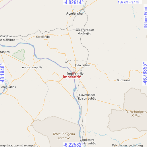
Imperatriz GPS coordinates[2]
5° 31' 35.004" South, 47° 29' 30.012" West
| Map corner | latitude | longitude |
|---|---|---|
| Upper-left | -4.82614°, | -48.1948° |
| Center: | -5.52639°, | -47.49167° |
| Lower-right: | -6.22582°, | -46.78855° |
| Map W x H: | 155.6×155.6 km | = 96.7×96.7mi |
| max Lat: | 2.81972° ⇑12.9% North |
| Imperatriz: | -5.52639° |
| min Lat: | ⇓87.1% South -33.69111° |
| min Long | Imperatriz | max Long |
| -72.89583° | -47.49167° | -32.41083° |
| W 38.2%⇐ | ⇒61.8% E |
Elevation
Elevation of Imperatriz is 127 m = 417 ft, and this is 253.9 m = 833 ft below average elevation for this country.
| Max E: |
1603 m = 5259 ft | 69.7% |
| Avg. | 380.9 m = 1250 ft | |
| Imperatriz | 127 m = 417 ft | |
Min E: |
0 m = 0 ft | 30.3% |
See also: Imperatriz elevation on elevation.city.
Geographical zone
Imperatriz is located in South Torrid zone (between Equator and Tropic of Capricorn). Distance of Equator is 614.5 km =381.8 mi to North.| Distance of | km | miles | from Imperatriz |
|---|---|---|---|
| Equator | 614.5 | 381.8 | to North |
| Tropic Capricorn | 1991.4 | 1237.4 | to South |
| Antarctic Circle | 6786.7 | 4217.1 | to South |
| South Pole | 9392.6 | 5836.3 | to South |


Nearby cities:
15 places around Imperatriz: (largest is in red/bold)
• Amarante do Maranhão
83.1 km =51.6 mi,  93°
93°
• Araguaína
201.3 km =125.1 mi,  203°
203°
• Balsas
275 km =170.9 mi,  144°
144°
• Barra do Corda
248.8 km =154.6 mi, 89°
• Bom Jardim
199.7 km =124.1 mi,  146°
146°
• Carolina
201.2 km =125 mi,  179°
179°
• Grajaú
153.2 km =95.2 mi,  102°
102°
• Itupiranga
207.8 km =129.1 mi,  282°
282°
• Marabá
182.3 km =113.3 mi, 275°
• Montes Altos
58.1 km =36.1 mi,  125°
125°
• Parauapebas
273.4 km =169.9 mi,  257°
257°
• Porto Franco
90.9 km =56.5 mi,  173°
173°
• Riachão
225.8 km =140.3 mi, 154°
• Santa Luzia
237.2 km =147.4 mi, 172°
• São Geraldo do Araguaia
152.6 km =94.8 mi,  230°
230°
Sources, notices
• [Note1] Compared only with cities in Brazil existing in our database
• [Src1] Map data: © OpenStreetMap contributors (CC-BY-SA)
• [Src2] Other city data from geonames.org with taken over terms of usage.
• [Src3] Geographical zone / Annual Mean Temperature by Robert A. Rohde @ Wikipedia
