Una geodata
Una (Bahia) is a populated place; located in Brazil in America/Bahia (GMT-3) time zone. With population of 22,613 people, there are 847 cities with bigger population in this country. Compared to other cities in Brazil, 55.5% of cities are located further ↓South; 79.6% of cities are located further ←West and 90.9% of cities have higher elevation than Una. Note1


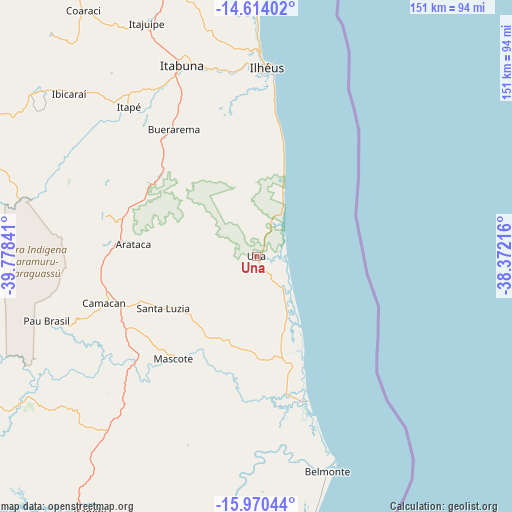
Una GPS coordinates[2]
15° 17' 35.988" South, 39° 4' 31.008" West
| Map corner | latitude | longitude |
|---|---|---|
| Upper-left | -14.61402°, | -39.77841° |
| Center: | -15.29333°, | -39.07528° |
| Lower-right: | -15.97044°, | -38.37216° |
| Map W x H: | 150.8×150.8 km | = 93.7×93.7mi |
| max Lat: | 2.81972° ⇑44.5% North |
| Una: | -15.29333° |
| min Lat: | ⇓55.5% South -33.69111° |
| min Long | Una | max Long |
| -72.89583° | -39.07528° | -32.41083° |
| W 79.6%⇐ | ⇒20.4% E |
Elevation
Elevation of Una is 16 m = 52 ft, and this is 364.9 m = 1197 ft below average elevation for this country.
| Max E: |
1603 m = 5259 ft | 90.9% |
| Avg. | 380.9 m = 1250 ft | |
| Una | 16 m = 52 ft | |
Min E: |
0 m = 0 ft | 9.1% |
See also: Brazil elevation on elevation.city.
Geographical zone
Una is located in South Torrid zone (between Equator and Tropic of Capricorn). Distance of this Southern Tropic circle is 905.5 km =562.7 mi to South.| Distance of | km | miles | from Una |
|---|---|---|---|
| Equator | 1700.5 | 1056.6 | to North |
| Tropic Capricorn | 905.5 | 562.7 | to South |
| Antarctic Circle | 5700.7 | 3542.2 | to South |
| South Pole | 8306.6 | 5161.5 | to South |


Nearby cities:
15 places around Una: (largest is in red/bold)
• Belmonte
66.5 km =41.3 mi,  161°
161°
• Buerarema
44.3 km =27.5 mi,  327°
327°
• Canavieiras
44.6 km =27.7 mi, 162°
• Coaraci
88.7 km =55.1 mi,  324°
324°
• Ibicaraí
72.7 km =45.2 mi,  310°
310°
• Ibicuí
110 km =68.4 mi,  297°
297°
• Ilhéus
55.7 km =34.6 mi,  3°
3°
• Itabuna
60.6 km =37.7 mi,  338°
338°
• Itajuípe
75.6 km =47 mi, 334°
• Itororó
108.5 km =67.4 mi,  280°
280°
• Mascote
38.6 km =24 mi,  219°
219°
• Pau Brasil
64.6 km =40.1 mi,  252°
252°
• Santa Cruz Cabrália
109.6 km =68.1 mi,  177°
177°
• Ubaitaba
112.3 km =69.8 mi,  346°
346°
• Uruçuca
81 km =50.3 mi, 343°
Sources, notices
• [Note1] Compared only with cities in Brazil existing in our database
• [Src1] Map data: © OpenStreetMap contributors (CC-BY-SA)
• [Src2] Other city data from geonames.org with taken over terms of usage.
• [Src3] Geographical zone / Annual Mean Temperature by Robert A. Rohde @ Wikipedia
