Itabuna geodata
Itabuna (Bahia) is a populated place; located in Brazil in America/Bahia (GMT-3) time zone. With population of 205,660 people, there are 110 cities with bigger population in this country. Compared to other cities in Brazil, 56.6% of cities are located further ↓South; 78.7% of cities are located further ←West and 76.4% of cities have higher elevation than Itabuna. Note1


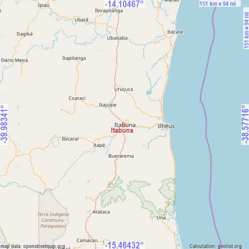
Itabuna GPS coordinates[2]
14° 47' 8.016" South, 39° 16' 49.008" West
| Map corner | latitude | longitude |
|---|---|---|
| Upper-left | -14.10467°, | -39.98341° |
| Center: | -14.78556°, | -39.28028° |
| Lower-right: | -15.46432°, | -38.57716° |
| Map W x H: | 151.2×151.2 km | = 94×94mi |
| max Lat: | 2.81972° ⇑43.4% North |
| Itabuna: | -14.78556° |
| min Lat: | ⇓56.6% South -33.69111° |
| min Long | Itabuna | max Long |
| -72.89583° | -39.28028° | -32.41083° |
| W 78.7%⇐ | ⇒21.3% E |
Elevation
Elevation of Itabuna is 69 m = 226 ft, and this is 311.9 m = 1023 ft below average elevation for this country.
| Max E: |
1603 m = 5259 ft | 76.4% |
| Avg. | 380.9 m = 1250 ft | |
| Itabuna | 69 m = 226 ft | |
Min E: |
0 m = 0 ft | 23.6% |
See also: Itabuna elevation on elevation.city.
Geographical zone
Itabuna is located in South Torrid zone (between Equator and Tropic of Capricorn). Distance of this Southern Tropic circle is 961.9 km =597.7 mi to South.| Distance of | km | miles | from Itabuna |
|---|---|---|---|
| Equator | 1644 | 1021.5 | to North |
| Tropic Capricorn | 961.9 | 597.7 | to South |
| Antarctic Circle | 5757.2 | 3577.4 | to South |
| South Pole | 8363.1 | 5196.6 | to South |


Nearby cities:
15 places around Itabuna: (largest is in red/bold)
• Buerarema
19.4 km =12.1 mi,  186°
186°
• Coaraci
33.3 km =20.7 mi,  298°
298°
• Ibicaraí
34.2 km =21.3 mi,  255°
255°
• Ibicuí
76.2 km =47.3 mi,  265°
265°
• Ibirapitanga
69.8 km =43.4 mi,  351°
351°
• Ilhéus
25.9 km =16.1 mi,  91°
91°
• Itacaré
64.1 km =39.8 mi,  28°
28°
• Itagibá
82.3 km =51.1 mi,  312°
312°
• Itajuípe
15.7 km =9.8 mi,  319°
319°
• Maraú
81 km =50.3 mi,  20°
20°
• Pau Brasil
85.3 km =53 mi,  207°
207°
• Ubaitaba
52.8 km =32.8 mi, 354°
• Ubatã
69.4 km =43.1 mi,  337°
337°
• Una
60.6 km =37.7 mi,  158°
158°
• Uruçuca
21.4 km =13.3 mi,  358°
358°
Sources, notices
• [Note1] Compared only with cities in Brazil existing in our database
• [Src1] Map data: © OpenStreetMap contributors (CC-BY-SA)
• [Src2] Other city data from geonames.org with taken over terms of usage.
• [Src3] Geographical zone / Annual Mean Temperature by Robert A. Rohde @ Wikipedia
