Santa Cruz Cabrália geodata
Santa Cruz Cabrália (Bahia) is a seat of a second-order administrative division; located in Brazil in America/Bahia (GMT-3) time zone. With population of 19,545 people, there are 960 cities with bigger population in this country. Compared to other cities in Brazil, 52.8% of cities are located further ↓South; 80% of cities are located further ←West and 80.8% of cities have higher elevation than Santa Cruz Cabrália. Note1


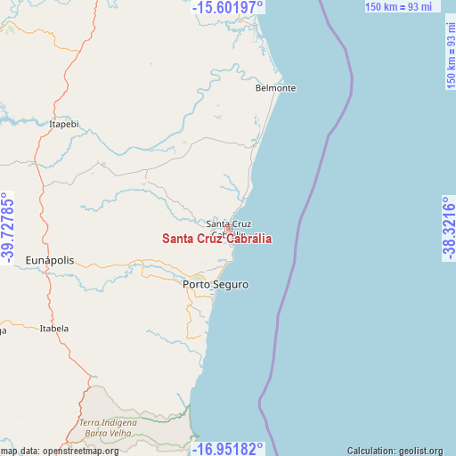
Santa Cruz Cabrália GPS coordinates[2]
16° 16' 41.016" South, 39° 1' 28.992" West
| Map corner | latitude | longitude |
|---|---|---|
| Upper-left | -15.60197°, | -39.72785° |
| Center: | -16.27806°, | -39.02472° |
| Lower-right: | -16.95182°, | -38.3216° |
| Map W x H: | 150.1×150.1 km | = 93.3×93.3mi |
| max Lat: | 2.81972° ⇑47.2% North |
| Santa Cruz Cabrália: | -16.27806° |
| min Lat: | ⇓52.8% South -33.69111° |
| min Long | Santa Cruz Cabr | max Long |
| -72.89583° | -39.02472° | -32.41083° |
| W 80%⇐ | ⇒20% E |
Elevation
Elevation of Santa Cruz Cabrália is 43 m = 141 ft, and this is 337.9 m = 1109 ft below average elevation for this country.
| Max E: |
1603 m = 5259 ft | 80.8% |
| Avg. | 380.9 m = 1250 ft | |
| Santa Cruz Cabrália | 43 m = 141 ft | |
Min E: |
0 m = 0 ft | 19.2% |
See also: Brazil elevation on elevation.city.
Geographical zone
Santa Cruz Cabrália is located in South Torrid zone (between Equator and Tropic of Capricorn). Distance of this Southern Tropic circle is 796 km =494.6 mi to South.| Distance of | km | miles | from Santa Cruz Cabrália |
|---|---|---|---|
| Equator | 1810 | 1124.7 | to North |
| Tropic Capricorn | 796 | 494.6 | to South |
| Antarctic Circle | 5591.2 | 3474.2 | to South |
| South Pole | 8197.1 | 5093.4 | to South |


Nearby cities:
15 places around Santa Cruz Cabrália: (largest is in red/bold)
• Belmonte
48.9 km =30.4 mi,  18°
18°
• Buerarema
149.5 km =92.9 mi,  348°
348°
• Canavieiras
67.6 km =42 mi,  7°
7°
• Eunápolis
60.3 km =37.5 mi,  259°
259°
• Guaratinga
87.7 km =54.5 mi,  247°
247°
• Ilhéus
165.1 km =102.6 mi,  359°
359°
• Itabuna
168.2 km =104.5 mi, 350°
• Itamaraju
100.4 km =62.4 mi,  212°
212°
• Itarantim
130.8 km =81.3 mi,  301°
301°
• Mascote
84.9 km =52.8 mi,  339°
339°
• Pau Brasil
112.6 km =70 mi,  323°
323°
• Porto Seguro
19.6 km =12.2 mi,  192°
192°
• Prado
120 km =74.6 mi, 190°
• Teixeira de Freitas
159.2 km =98.9 mi, 208°
• Una
109.6 km =68.1 mi, 357°
Sources, notices
• [Note1] Compared only with cities in Brazil existing in our database
• [Src1] Map data: © OpenStreetMap contributors (CC-BY-SA)
• [Src2] Other city data from geonames.org with taken over terms of usage.
• [Src3] Geographical zone / Annual Mean Temperature by Robert A. Rohde @ Wikipedia
