Ilhéus geodata
Ilhéus (Bahia) is a populated place; located in Brazil in America/Bahia (GMT-3) time zone. With population of 155,499 people, there are 148 cities with bigger population in this country. Compared to other cities in Brazil, 56.6% of cities are located further ↓South; 79.9% of cities are located further ←West and 86.4% of cities have higher elevation than Ilhéus. Note1


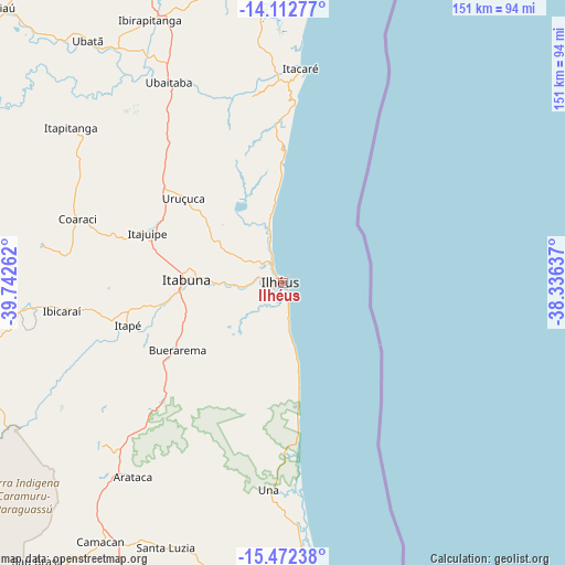
Ilhéus GPS coordinates[2]
14° 47' 37.104" South, 39° 2' 22.164" West
| Map corner | latitude | longitude |
|---|---|---|
| Upper-left | -14.11277°, | -39.74262° |
| Center: | -14.79364°, | -39.03949° |
| Lower-right: | -15.47238°, | -38.33637° |
| Map W x H: | 151.2×151.2 km | = 94×94mi |
| max Lat: | 2.81972° ⇑43.4% North |
| Ilhéus: | -14.79364° |
| min Lat: | ⇓56.6% South -33.69111° |
| min Long | Ilhéus | max Long |
| -72.89583° | -39.03949° | -32.41083° |
| W 79.9%⇐ | ⇒20.1% E |
Elevation
Elevation of Ilhéus is 26 m = 85 ft, and this is 354.9 m = 1164 ft below average elevation for this country.
| Max E: |
1603 m = 5259 ft | 86.4% |
| Avg. | 380.9 m = 1250 ft | |
| Ilhéus | 26 m = 85 ft | |
Min E: |
0 m = 0 ft | 13.6% |
See also: Ilhéus elevation on elevation.city.
Geographical zone
Ilhéus is located in South Torrid zone (between Equator and Tropic of Capricorn). Distance of this Southern Tropic circle is 961 km =597.1 mi to South.| Distance of | km | miles | from Ilhéus |
|---|---|---|---|
| Equator | 1644.9 | 1022.1 | to North |
| Tropic Capricorn | 961 | 597.1 | to South |
| Antarctic Circle | 5756.3 | 3576.8 | to South |
| South Pole | 8362.2 | 5196 | to South |


Nearby cities:
15 places around Ilhéus: (largest is in red/bold)
• Buerarema
33.5 km =20.8 mi,  236°
236°
• Camamu
94.6 km =58.8 mi,  355°
355°
• Canavieiras
98.5 km =61.2 mi,  174°
174°
• Coaraci
57.6 km =35.8 mi,  287°
287°
• Ibicaraí
59.4 km =36.9 mi,  262°
262°
• Ibirapitanga
78.7 km =48.9 mi,  332°
332°
• Itabuna
25.9 km =16.1 mi,  271°
271°
• Itacaré
57.4 km =35.7 mi,  4°
4°
• Itajuípe
38.3 km =23.8 mi, 289°
• Maraú
76.7 km =47.7 mi, 1°
• Mascote
90.1 km =56 mi,  198°
198°
• Ubaitaba
61.6 km =38.3 mi, 330°
• Ubatã
83.5 km =51.9 mi,  321°
321°
• Una
55.7 km =34.6 mi,  183°
183°
• Uruçuca
34.5 km =21.4 mi,  310°
310°
Sources, notices
• [Note1] Compared only with cities in Brazil existing in our database
• [Src1] Map data: © OpenStreetMap contributors (CC-BY-SA)
• [Src2] Other city data from geonames.org with taken over terms of usage.
• [Src3] Geographical zone / Annual Mean Temperature by Robert A. Rohde @ Wikipedia
