Buerarema geodata
Buerarema (Bahia) is a populated place; located in Brazil in America/Bahia (GMT-3) time zone. With population of 16,001 people, there are 1158 cities with bigger population in this country. Compared to other cities in Brazil, 56.1% of cities are located further ↓South; 78.4% of cities are located further ←West and 71.4% of cities have higher elevation than Buerarema. Note1


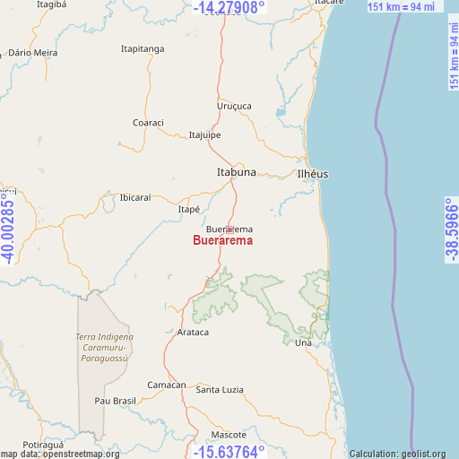
Buerarema GPS coordinates[2]
14° 57' 33.984" South, 39° 17' 58.992" West
| Map corner | latitude | longitude |
|---|---|---|
| Upper-left | -14.27908°, | -40.00285° |
| Center: | -14.95944°, | -39.29972° |
| Lower-right: | -15.63764°, | -38.5966° |
| Map W x H: | 151.1×151.1 km | = 93.9×93.9mi |
| max Lat: | 2.81972° ⇑43.9% North |
| Buerarema: | -14.95944° |
| min Lat: | ⇓56.1% South -33.69111° |
| min Long | Buerarema | max Long |
| -72.89583° | -39.29972° | -32.41083° |
| W 78.4%⇐ | ⇒21.6% E |
Elevation
Elevation of Buerarema is 111 m = 364 ft, and this is 269.9 m = 885 ft below average elevation for this country.
| Max E: |
1603 m = 5259 ft | 71.4% |
| Avg. | 380.9 m = 1250 ft | |
| Buerarema | 111 m = 364 ft | |
Min E: |
0 m = 0 ft | 28.6% |
See also: Brazil elevation on elevation.city.
Geographical zone
Buerarema is located in South Torrid zone (between Equator and Tropic of Capricorn). Distance of this Southern Tropic circle is 942.6 km =585.7 mi to South.| Distance of | km | miles | from Buerarema |
|---|---|---|---|
| Equator | 1663.3 | 1033.5 | to North |
| Tropic Capricorn | 942.6 | 585.7 | to South |
| Antarctic Circle | 5737.8 | 3565.3 | to South |
| South Pole | 8343.7 | 5184.5 | to South |


Nearby cities:
15 places around Buerarema: (largest is in red/bold)
• Coaraci
44.6 km =27.7 mi,  322°
322°
• Ibicaraí
32.7 km =20.3 mi,  288°
288°
• Ibicuí
75 km =46.6 mi,  280°
280°
• Iguaí
87.8 km =54.6 mi, 284°
• Ilhéus
33.5 km =20.8 mi,  56°
56°
• Itabuna
19.4 km =12.1 mi,  6°
6°
• Itacaré
82.4 km =51.2 mi,  23°
23°
• Itajuípe
32.3 km =20.1 mi,  345°
345°
• Itororó
84.6 km =52.6 mi,  258°
258°
• Mascote
67.1 km =41.7 mi,  180°
180°
• Pau Brasil
67.6 km =42 mi,  213°
213°
• Ubaitaba
72 km =44.7 mi,  357°
357°
• Ubatã
86.9 km =54 mi,  343°
343°
• Una
44.3 km =27.5 mi,  147°
147°
• Uruçuca
40.8 km =25.4 mi,  2°
2°
Sources, notices
• [Note1] Compared only with cities in Brazil existing in our database
• [Src1] Map data: © OpenStreetMap contributors (CC-BY-SA)
• [Src2] Other city data from geonames.org with taken over terms of usage.
• [Src3] Geographical zone / Annual Mean Temperature by Robert A. Rohde @ Wikipedia
