Itororó geodata
Itororó (Bahia) is a populated place; located in Brazil in America/Bahia (GMT-3) time zone. With population of 17,324 people, there are 1074 cities with bigger population in this country. Compared to other cities in Brazil, 55.9% of cities are located further ↓South; 75.3% of cities are located further ←West and 56.1% of cities have higher elevation than Itororó. Note1


Itororó GPS coordinates[2]
15° 7' 0.984" South, 40° 4' 13.008" West
| Map corner | latitude | longitude |
|---|---|---|
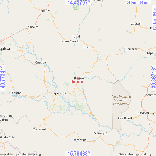
| Upper-left | -14.43707°, | -40.77341° |
| Center: | -15.11694°, | -40.07028° |
| Lower-right: | -15.79463°, | -39.36716° |
| Map W x H: | 150.9×150.9 km | = 93.8×93.8mi |
| max Lat: | 2.81972° ⇑44.1% North |
| Itororó: | -15.11694° |
| min Lat: | ⇓55.9% South -33.69111° |
| min Long | Itororó | max Long |
| -72.89583° | -40.07028° | -32.41083° |
| W 75.3%⇐ | ⇒24.7% E |
Elevation
Elevation of Itororó is 253 m = 830 ft, and this is 127.9 m = 420 ft below average elevation for this country.
| Max E: |
1603 m = 5259 ft | 56.1% |
| Avg. | 380.9 m = 1250 ft | |
| Itororó | 253 m = 830 ft | |
Min E: |
0 m = 0 ft | 43.9% |
See also: Brazil elevation on elevation.city.
Geographical zone
Itororó is located in South Torrid zone (between Equator and Tropic of Capricorn). Distance of this Southern Tropic circle is 925.1 km =574.8 mi to South.| Distance of | km | miles | from Itororó |
|---|---|---|---|
| Equator | 1680.8 | 1044.4 | to North |
| Tropic Capricorn | 925.1 | 574.8 | to South |
| Antarctic Circle | 5720.3 | 3554.4 | to South |
| South Pole | 8326.2 | 5173.7 | to South |


Nearby cities:
15 places around Itororó: (largest is in red/bold)
• Buerarema
84.6 km =52.6 mi,  78°
78°
• Coaraci
76.9 km =47.8 mi,  46°
46°
• Ibicaraí
58.9 km =36.6 mi,  61°
61°
• Ibicuí
31.9 km =19.8 mi,  16°
16°
• Iguaí
40.1 km =24.9 mi,  357°
357°
• Itabuna
92.5 km =57.5 mi,  66°
66°
• Itagibá
95.8 km =59.5 mi,  14°
14°
• Itajuípe
89.2 km =55.4 mi, 56°
• Itambé
61.1 km =38 mi,  256°
256°
• Itapetinga
24 km =14.9 mi,  232°
232°
• Itarantim
60.4 km =37.5 mi,  179°
179°
• Mascote
96.1 km =59.7 mi,  121°
121°
• Pau Brasil
59.3 km =36.8 mi,  130°
130°
• Poções
72.6 km =45.1 mi,  334°
334°
• Vitória da Conquista
87.2 km =54.2 mi,  288°
288°
Sources, notices
• [Note1] Compared only with cities in Brazil existing in our database
• [Src1] Map data: © OpenStreetMap contributors (CC-BY-SA)
• [Src2] Other city data from geonames.org with taken over terms of usage.
• [Src3] Geographical zone / Annual Mean Temperature by Robert A. Rohde @ Wikipedia
