Belmonte geodata
Belmonte (Bahia) is a populated place; located in Brazil in America/Bahia (GMT-3) time zone. With population of 9,806 people, there are 1664 cities with bigger population in this country. Compared to other cities in Brazil, 53.8% of cities are located further ↓South; 81% of cities are located further ←West and 99.9% of cities have higher elevation than Belmonte. Note1


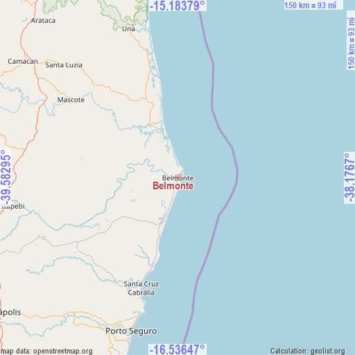
Belmonte GPS coordinates[2]
15° 51' 40.536" South, 38° 52' 47.352" West
| Map corner | latitude | longitude |
|---|---|---|
| Upper-left | -15.18379°, | -39.58295° |
| Center: | -15.86126°, | -38.87982° |
| Lower-right: | -16.53647°, | -38.1767° |
| Map W x H: | 150.4×150.4 km | = 93.5×93.5mi |
| max Lat: | 2.81972° ⇑46.2% North |
| Belmonte: | -15.86126° |
| min Lat: | ⇓53.8% South -33.69111° |
| min Long | Belmonte | max Long |
| -72.89583° | -38.87982° | -32.41083° |
| W 81%⇐ | ⇒19% E |
Elevation
Elevation of Belmonte is 1 m = 3 ft, and this is 379.9 m = 1246 ft below average elevation for this country.
| Max E: |
1603 m = 5259 ft | 99.9% |
| Avg. | 380.9 m = 1250 ft | |
| Belmonte | 1 m = 3 ft | |
Min E: |
0 m = 0 ft | 0.1% |
See also: Brazil elevation on elevation.city.
Geographical zone
Belmonte is located in South Torrid zone (between Equator and Tropic of Capricorn). Distance of this Southern Tropic circle is 842.3 km =523.4 mi to South.| Distance of | km | miles | from Belmonte |
|---|---|---|---|
| Equator | 1763.6 | 1095.8 | to North |
| Tropic Capricorn | 842.3 | 523.4 | to South |
| Antarctic Circle | 5637.6 | 3503 | to South |
| South Pole | 8243.5 | 5122.3 | to South |


Nearby cities:
15 places around Belmonte: (largest is in red/bold)
• Buerarema
109.9 km =68.3 mi,  335°
335°
• Canavieiras
21.9 km =13.6 mi, 340°
• Eunápolis
94.3 km =58.6 mi,  232°
232°
• Guaratinga
125.5 km =78 mi, 230°
• Ibicaraí
134.3 km =83.5 mi,  325°
325°
• Ilhéus
119.9 km =74.5 mi,  351°
351°
• Itabuna
127.1 km =79 mi, 340°
• Itajuípe
141.9 km =88.2 mi, 338°
• Itarantim
128.8 km =80 mi,  280°
280°
• Mascote
56.1 km =34.9 mi,  306°
306°
• Pau Brasil
93.6 km =58.2 mi,  298°
298°
• Porto Seguro
68.3 km =42.4 mi,  196°
196°
• Santa Cruz Cabrália
48.9 km =30.4 mi, 198°
• Una
66.5 km =41.3 mi, 341°
• Uruçuca
147.5 km =91.7 mi, 342°
Sources, notices
• [Note1] Compared only with cities in Brazil existing in our database
• [Src1] Map data: © OpenStreetMap contributors (CC-BY-SA)
• [Src2] Other city data from geonames.org with taken over terms of usage.
• [Src3] Geographical zone / Annual Mean Temperature by Robert A. Rohde @ Wikipedia
