Gandu geodata
Gandu (Bahia) is a populated place; located in Brazil in America/Bahia (GMT-3) time zone. With population of 21,565 people, there are 884 cities with bigger population in this country. Compared to other cities in Brazil, 58.6% of cities are located further ↓South; 77.4% of cities are located further ←West and 66% of cities have higher elevation than Gandu. Note1


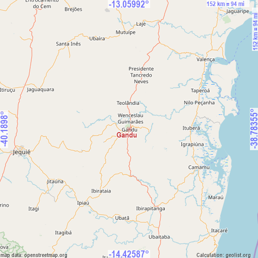
Gandu GPS coordinates[2]
13° 44' 38.004" South, 39° 29' 12.012" West
| Map corner | latitude | longitude |
|---|---|---|
| Upper-left | -13.05992°, | -40.1898° |
| Center: | -13.74389°, | -39.48667° |
| Lower-right: | -14.42587°, | -38.78355° |
| Map W x H: | 151.9×151.9 km | = 94.4×94.4mi |
| max Lat: | 2.81972° ⇑41.4% North |
| Gandu: | -13.74389° |
| min Lat: | ⇓58.6% South -33.69111° |
| min Long | Gandu | max Long |
| -72.89583° | -39.48667° | -32.41083° |
| W 77.4%⇐ | ⇒22.6% E |
Elevation
Elevation of Gandu is 159 m = 522 ft, and this is 221.9 m = 728 ft below average elevation for this country.
| Max E: |
1603 m = 5259 ft | 66% |
| Avg. | 380.9 m = 1250 ft | |
| Gandu | 159 m = 522 ft | |
Min E: |
0 m = 0 ft | 34% |
See also: Brazil elevation on elevation.city.
Geographical zone
Gandu is located in South Torrid zone (between Equator and Tropic of Capricorn). Distance of this Southern Tropic circle is 1077.7 km =669.7 mi to South.| Distance of | km | miles | from Gandu |
|---|---|---|---|
| Equator | 1528.2 | 949.6 | to North |
| Tropic Capricorn | 1077.7 | 669.7 | to South |
| Antarctic Circle | 5873 | 3649.3 | to South |
| South Pole | 8478.9 | 5268.5 | to South |


Nearby cities:
15 places around Gandu: (largest is in red/bold)
• Camamu
47 km =29.2 mi,  118°
118°
• Ibirapitanga
48.3 km =30 mi,  165°
165°
• Ibirataia
39.6 km =24.6 mi,  204°
204°
• Ipiaú
51.3 km =31.9 mi,  212°
212°
• Ituberá
36.6 km =22.7 mi,  88°
88°
• Jaguaquara
57.4 km =35.7 mi,  294°
294°
• Jitaúna
53.6 km =33.3 mi,  236°
236°
• Maraú
64.8 km =40.3 mi,  128°
128°
• Mutuípe
57.3 km =35.6 mi,  358°
358°
• Santa Inês
61.7 km =38.3 mi,  324°
324°
• Taperoá
47.8 km =29.7 mi,  61°
61°
• Ubaitaba
65.6 km =40.8 mi,  164°
164°
• Ubatã
51.9 km =32.2 mi,  184°
184°
• Ubaíra
56.2 km =34.9 mi,  340°
340°
• Valença
61 km =37.9 mi,  47°
47°
Sources, notices
• [Note1] Compared only with cities in Brazil existing in our database
• [Src1] Map data: © OpenStreetMap contributors (CC-BY-SA)
• [Src2] Other city data from geonames.org with taken over terms of usage.
• [Src3] Geographical zone / Annual Mean Temperature by Robert A. Rohde @ Wikipedia
