Itacaré geodata
Itacaré (Bahia) is a populated place; located in Brazil in America/Bahia (GMT-3) time zone. With population of 12,484 people, there are 1424 cities with bigger population in this country. Compared to other cities in Brazil, 57.7% of cities are located further ↓South; 80.3% of cities are located further ←West and 87.3% of cities have higher elevation than Itacaré. Note1


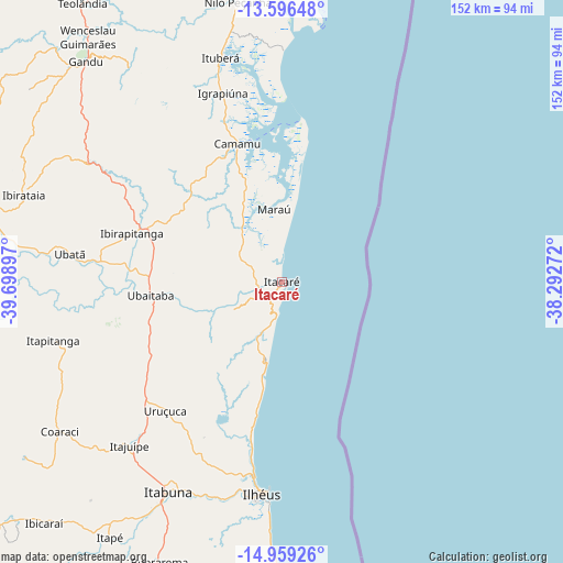
Itacaré GPS coordinates[2]
14° 16' 44.04" South, 38° 59' 45.024" West
| Map corner | latitude | longitude |
|---|---|---|
| Upper-left | -13.59648°, | -39.69897° |
| Center: | -14.2789°, | -38.99584° |
| Lower-right: | -14.95926°, | -38.29272° |
| Map W x H: | 151.5×151.5 km | = 94.1×94.1mi |
| max Lat: | 2.81972° ⇑42.3% North |
| Itacaré: | -14.2789° |
| min Lat: | ⇓57.7% South -33.69111° |
| min Long | Itacaré | max Long |
| -72.89583° | -38.99584° | -32.41083° |
| W 80.3%⇐ | ⇒19.7% E |
Elevation
Elevation of Itacaré is 23 m = 75 ft, and this is 357.9 m = 1174 ft below average elevation for this country.
| Max E: |
1603 m = 5259 ft | 87.3% |
| Avg. | 380.9 m = 1250 ft | |
| Itacaré | 23 m = 75 ft | |
Min E: |
0 m = 0 ft | 12.7% |
See also: Brazil elevation on elevation.city.
Geographical zone
Itacaré is located in South Torrid zone (between Equator and Tropic of Capricorn). Distance of this Southern Tropic circle is 1018.3 km =632.7 mi to South.| Distance of | km | miles | from Itacaré |
|---|---|---|---|
| Equator | 1587.7 | 986.6 | to North |
| Tropic Capricorn | 1018.3 | 632.7 | to South |
| Antarctic Circle | 5813.5 | 3612.3 | to South |
| South Pole | 8419.4 | 5231.6 | to South |


Nearby cities:
15 places around Itacaré: (largest is in red/bold)
• Buerarema
82.4 km =51.2 mi,  203°
203°
• Camamu
38.9 km =24.2 mi,  342°
342°
• Coaraci
72.1 km =44.8 mi,  236°
236°
• Gandu
79.6 km =49.5 mi,  318°
318°
• Ibirapitanga
42.7 km =26.5 mi,  287°
287°
• Ibirataia
73.4 km =45.6 mi, 288°
• Ilhéus
57.4 km =35.7 mi,  184°
184°
• Ipiaú
81.7 km =50.8 mi,  281°
281°
• Itabuna
64.1 km =39.8 mi,  208°
208°
• Itajuípe
60.3 km =37.5 mi,  222°
222°
• Ituberá
62.6 km =38.9 mi, 344°
• Maraú
19.6 km =12.2 mi,  353°
353°
• Ubaitaba
35.5 km =22.1 mi,  263°
263°
• Ubatã
57.7 km =35.9 mi, 277°
• Uruçuca
46.8 km =29.1 mi, 221°
Sources, notices
• [Note1] Compared only with cities in Brazil existing in our database
• [Src1] Map data: © OpenStreetMap contributors (CC-BY-SA)
• [Src2] Other city data from geonames.org with taken over terms of usage.
• [Src3] Geographical zone / Annual Mean Temperature by Robert A. Rohde @ Wikipedia
