Camamu geodata
Camamu (Bahia) is a populated place; located in Brazil in America/Bahia (GMT-3) time zone. With population of 13,924 people, there are 1296 cities with bigger population in this country. Compared to other cities in Brazil, 58.4% of cities are located further ↓South; 79.4% of cities are located further ←West and 82.5% of cities have higher elevation than Camamu. Note1


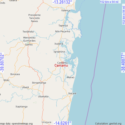
Camamu GPS coordinates[2]
13° 56' 40.992" South, 39° 6' 14.004" West
| Map corner | latitude | longitude |
|---|---|---|
| Upper-left | -13.26132°, | -39.80702° |
| Center: | -13.94472°, | -39.10389° |
| Lower-right: | -14.6261°, | -38.40077° |
| Map W x H: | 151.7×151.8 km | = 94.3×94.3mi |
| max Lat: | 2.81972° ⇑41.6% North |
| Camamu: | -13.94472° |
| min Lat: | ⇓58.4% South -33.69111° |
| min Long | Camamu | max Long |
| -72.89583° | -39.10389° | -32.41083° |
| W 79.4%⇐ | ⇒20.6% E |
Elevation
Elevation of Camamu is 37 m = 121 ft, and this is 343.9 m = 1128 ft below average elevation for this country.
| Max E: |
1603 m = 5259 ft | 82.5% |
| Avg. | 380.9 m = 1250 ft | |
| Camamu | 37 m = 121 ft | |
Min E: |
0 m = 0 ft | 17.5% |
See also: Brazil elevation on elevation.city.
Geographical zone
Camamu is located in South Torrid zone (between Equator and Tropic of Capricorn). Distance of this Southern Tropic circle is 1055.4 km =655.8 mi to South.| Distance of | km | miles | from Camamu |
|---|---|---|---|
| Equator | 1550.5 | 963.4 | to North |
| Tropic Capricorn | 1055.4 | 655.8 | to South |
| Antarctic Circle | 5850.7 | 3635.5 | to South |
| South Pole | 8456.6 | 5254.7 | to South |


Nearby cities:
15 places around Camamu: (largest is in red/bold)
• Gandu
47 km =29.2 mi,  298°
298°
• Ibirapitanga
38 km =23.6 mi,  230°
230°
• Ibirataia
59.5 km =37 mi,  256°
256°
• Ipiaú
71.7 km =44.6 mi,  252°
252°
• Itacaré
38.9 km =24.2 mi,  162°
162°
• Itagibá
88.1 km =54.7 mi,  244°
244°
• Itajuípe
86.6 km =53.8 mi,  199°
199°
• Ituberá
23.8 km =14.8 mi,  348°
348°
• Jitaúna
86.1 km =53.5 mi, 264°
• Maraú
20.1 km =12.5 mi,  151°
151°
• Taperoá
45.2 km =28.1 mi,  0°
0°
• Ubaitaba
47.2 km =29.3 mi,  210°
210°
• Ubatã
54.2 km =33.7 mi, 237°
• Uruçuca
74.7 km =46.4 mi, 195°
• Valença
64 km =39.8 mi, 2°
Sources, notices
• [Note1] Compared only with cities in Brazil existing in our database
• [Src1] Map data: © OpenStreetMap contributors (CC-BY-SA)
• [Src2] Other city data from geonames.org with taken over terms of usage.
• [Src3] Geographical zone / Annual Mean Temperature by Robert A. Rohde @ Wikipedia
