Ituberá geodata
Ituberá (Bahia) is a populated place; located in Brazil in America/Bahia (GMT-3) time zone. With population of 19,887 people, there are 945 cities with bigger population in this country. Compared to other cities in Brazil, 58.7% of cities are located further ↓South; 79.3% of cities are located further ←West and 97.2% of cities have higher elevation than Ituberá. Note1


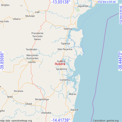
Ituberá GPS coordinates[2]
13° 44' 7.368" South, 39° 8' 52.26" West
| Map corner | latitude | longitude |
|---|---|---|
| Upper-left | -13.05138°, | -39.85098° |
| Center: | -13.73538°, | -39.14785° |
| Lower-right: | -14.41739°, | -38.44473° |
| Map W x H: | 151.9×151.9 km | = 94.4×94.4mi |
| max Lat: | 2.81972° ⇑41.3% North |
| Ituberá: | -13.73538° |
| min Lat: | ⇓58.7% South -33.69111° |
| min Long | Ituberá | max Long |
| -72.89583° | -39.14785° | -32.41083° |
| W 79.3%⇐ | ⇒20.7% E |
Elevation
Elevation of Ituberá is 7 m = 23 ft, and this is 373.9 m = 1227 ft below average elevation for this country.
| Max E: |
1603 m = 5259 ft | 97.2% |
| Avg. | 380.9 m = 1250 ft | |
| Ituberá | 7 m = 23 ft | |
Min E: |
0 m = 0 ft | 2.8% |
See also: Brazil elevation on elevation.city.
Geographical zone
Ituberá is located in South Torrid zone (between Equator and Tropic of Capricorn). Distance of this Southern Tropic circle is 1078.7 km =670.3 mi to South.| Distance of | km | miles | from Ituberá |
|---|---|---|---|
| Equator | 1527.2 | 949 | to North |
| Tropic Capricorn | 1078.7 | 670.3 | to South |
| Antarctic Circle | 5873.9 | 3649.9 | to South |
| South Pole | 8479.8 | 5269.1 | to South |


Nearby cities:
15 places around Ituberá: (largest is in red/bold)
• Camamu
23.8 km =14.8 mi,  168°
168°
• Gandu
36.6 km =22.7 mi,  268°
268°
• Ibirapitanga
53.5 km =33.2 mi,  207°
207°
• Ibirataia
64.7 km =40.2 mi,  235°
235°
• Ipiaú
77.8 km =48.3 mi, 235°
• Itacaré
62.6 km =38.9 mi,  164°
164°
• Maraú
43.4 km =27 mi, 160°
• Mutuípe
68.3 km =42.4 mi,  325°
325°
• Nazaré
79.2 km =49.2 mi,  10°
10°
• Santo Antônio de Jesus
86.1 km =53.5 mi,  351°
351°
• Taperoá
22.6 km =14 mi, 13°
• Ubaitaba
66.9 km =41.6 mi,  196°
196°
• Ubatã
66.7 km =41.4 mi,  217°
217°
• Ubaíra
76.2 km =47.3 mi,  313°
313°
• Valença
41.4 km =25.7 mi, 11°
Sources, notices
• [Note1] Compared only with cities in Brazil existing in our database
• [Src1] Map data: © OpenStreetMap contributors (CC-BY-SA)
• [Src2] Other city data from geonames.org with taken over terms of usage.
• [Src3] Geographical zone / Annual Mean Temperature by Robert A. Rohde @ Wikipedia
