Maraú geodata
Maraú (Bahia) is a populated place; located in Brazil in America/Bahia (GMT-3) time zone. With population of 2,956 people, there are 1993 cities with bigger population in this country. Compared to other cities in Brazil, 58.1% of cities are located further ↓South; 80.1% of cities are located further ←West and 84.1% of cities have higher elevation than Maraú. Note1


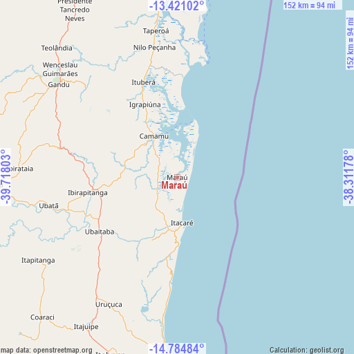
Maraú GPS coordinates[2]
14° 6' 14.22" South, 39° 0' 53.64" West
| Map corner | latitude | longitude |
|---|---|---|
| Upper-left | -13.42102°, | -39.71803° |
| Center: | -14.10395°, | -39.0149° |
| Lower-right: | -14.78484°, | -38.31178° |
| Map W x H: | 151.6×151.6 km | = 94.2×94.2mi |
| max Lat: | 2.81972° ⇑41.9% North |
| Maraú: | -14.10395° |
| min Lat: | ⇓58.1% South -33.69111° |
| min Long | Maraú | max Long |
| -72.89583° | -39.0149° | -32.41083° |
| W 80.1%⇐ | ⇒19.9% E |
Elevation
Elevation of Maraú is 33 m = 108 ft, and this is 347.9 m = 1141 ft below average elevation for this country.
| Max E: |
1603 m = 5259 ft | 84.1% |
| Avg. | 380.9 m = 1250 ft | |
| Maraú | 33 m = 108 ft | |
Min E: |
0 m = 0 ft | 15.9% |
See also: Brazil elevation on elevation.city.
Geographical zone
Maraú is located in South Torrid zone (between Equator and Tropic of Capricorn). Distance of this Southern Tropic circle is 1037.7 km =644.8 mi to South.| Distance of | km | miles | from Maraú |
|---|---|---|---|
| Equator | 1568.2 | 974.4 | to North |
| Tropic Capricorn | 1037.7 | 644.8 | to South |
| Antarctic Circle | 5833 | 3624.5 | to South |
| South Pole | 8438.8 | 5243.6 | to South |


Nearby cities:
15 places around Maraú: (largest is in red/bold)
• Camamu
20.1 km =12.5 mi,  331°
331°
• Gandu
64.8 km =40.3 mi,  308°
308°
• Ibirapitanga
39.3 km =24.4 mi,  260°
260°
• Ibirataia
67.6 km =42 mi,  273°
273°
• Ilhéus
76.7 km =47.7 mi,  181°
181°
• Ipiaú
78.2 km =48.6 mi, 267°
• Itabuna
81 km =50.3 mi,  200°
200°
• Itacaré
19.6 km =12.2 mi,  173°
173°
• Itajuípe
74.7 km =46.4 mi,  211°
211°
• Ituberá
43.4 km =27 mi,  340°
340°
• Taperoá
63.6 km =39.5 mi,  351°
351°
• Ubaitaba
40.5 km =25.2 mi,  235°
235°
• Ubatã
56.4 km =35 mi, 258°
• Uruçuca
61.6 km =38.3 mi, 208°
• Valença
81.8 km =50.8 mi,  355°
355°
Sources, notices
• [Note1] Compared only with cities in Brazil existing in our database
• [Src1] Map data: © OpenStreetMap contributors (CC-BY-SA)
• [Src2] Other city data from geonames.org with taken over terms of usage.
• [Src3] Geographical zone / Annual Mean Temperature by Robert A. Rohde @ Wikipedia
