Altãnia geodata
Altãnia (Paraná) is a populated place; located in Brazil in America/Sao_Paulo (GMT-3) time zone. With population of 11,242 people, there are 1542 cities with bigger population in this country. Compared to other cities in Brazil, 85.6% of cities are located further ↑North; 92.3% of cities are located further →East and 50% of cities have lower elevation than Altãnia. Note1


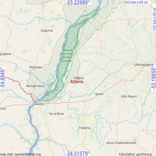
Altãnia GPS coordinates[2]
23° 52' 27.984" South, 53° 54' 6.012" West
| Map corner | latitude | longitude |
|---|---|---|
| Upper-left | -23.22989°, | -54.6048° |
| Center: | -23.87444°, | -53.90167° |
| Lower-right: | -24.51579°, | -53.19855° |
| Map W x H: | 143×143 km | = 88.9×88.9mi |
| max Lat: | 2.81972° ⇑85.6% North |
| Altãnia: | -23.87444° |
| min Lat: | ⇓14.4% South -33.69111° |
| min Long | Altãnia | max Long |
| -72.89583° | -53.90167° | -32.41083° |
| W 7.7%⇐ | ⇒92.3% E |
Elevation
Elevation of Altãnia is 353 m = 1158 ft, and this is 27.9 m = 92 ft below average elevation for this country.
| Max E: |
1603 m = 5259 ft | 50% |
| Avg. | 380.9 m = 1250 ft | |
| Altãnia | 353 m = 1158 ft | |
Min E: |
0 m = 0 ft | 50% |
See also: Brazil elevation on elevation.city.
Geographical zone
Altãnia is located in South temperate zone (between Tropic of Capricorn and the Antarctic Circle). Distance of this Southern Tropic circle is 48.7 km =30.3 mi to North.| Distance of | km | miles | from Altãnia |
|---|---|---|---|
| Equator | 2654.6 | 1649.5 | to North |
| Tropic Capricorn | 48.7 | 30.3 | to North |
| Antarctic Circle | 4746.6 | 2949.4 | to South |
| South Pole | 7352.5 | 4568.6 | to South |


Nearby cities:
15 places around Altãnia: (largest is in red/bold)
• Alto Piquiri
49.9 km =31 mi,  110°
110°
• Corbélia
119.2 km =74.1 mi,  149°
149°
• Costa Rica
91.7 km =57 mi,  303°
303°
• Cruzeiro do Oeste
84.8 km =52.7 mi,  83°
83°
• Eldorado
40 km =24.9 mi,  284°
284°
• Iguatemi
70.5 km =43.8 mi,  287°
287°
• Iporã
24.6 km =15.3 mi,  125°
125°
• Marechal Cândido Rondon
77.4 km =48.1 mi,  191°
191°
• Moreira Sales
93.3 km =58 mi,  102°
102°
• Naviraí
94.7 km =58.8 mi,  341°
341°
• Palotina
46 km =28.6 mi,  172°
172°
• Pôrto Barra do Ivinheima
103.7 km =64.4 mi,  13°
13°
• Tapejara
105.8 km =65.7 mi, 81°
• Toledo
94.7 km =58.8 mi, 170°
• Umuarama
59.9 km =37.2 mi, 78°
Sources, notices
• [Note1] Compared only with cities in Brazil existing in our database
• [Src1] Map data: © OpenStreetMap contributors (CC-BY-SA)
• [Src2] Other city data from geonames.org with taken over terms of usage.
• [Src3] Geographical zone / Annual Mean Temperature by Robert A. Rohde @ Wikipedia
