Eldorado geodata
Eldorado (Mato Grosso do Sul) is a populated place; located in Brazil in America/Campo_Grande (GMT-4) time zone. With population of 9,075 people, there are 1713 cities with bigger population in this country. Compared to other cities in Brazil, 85% of cities are located further ↑North; 93.1% of cities are located further →East and 50.2% of cities have higher elevation than Eldorado. Note1


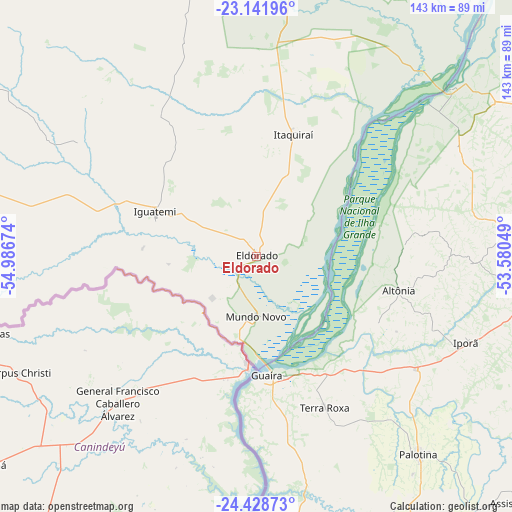
Eldorado GPS coordinates[2]
23° 47' 12.984" South, 54° 17' 0.996" West
| Map corner | latitude | longitude |
|---|---|---|
| Upper-left | -23.14196°, | -54.98674° |
| Center: | -23.78694°, | -54.28361° |
| Lower-right: | -24.42873°, | -53.58049° |
| Map W x H: | 143.1×143.1 km | = 88.9×88.9mi |
| max Lat: | 2.81972° ⇑85% North |
| Eldorado: | -23.78694° |
| min Lat: | ⇓15% South -33.69111° |
| min Long | Eldorado | max Long |
| -72.89583° | -54.28361° | -32.41083° |
| W 6.9%⇐ | ⇒93.1% E |
Elevation
Elevation of Eldorado is 350 m = 1148 ft, and this is 30.9 m = 101 ft below average elevation for this country.
| Max E: |
1603 m = 5259 ft | 50.2% |
| Avg. | 380.9 m = 1250 ft | |
| Eldorado | 350 m = 1148 ft | |
Min E: |
0 m = 0 ft | 49.8% |
See also: Brazil elevation on elevation.city.
Geographical zone
Eldorado is located in South temperate zone (between Tropic of Capricorn and the Antarctic Circle). Distance of this Southern Tropic circle is 38.9 km =24.2 mi to North.| Distance of | km | miles | from Eldorado |
|---|---|---|---|
| Equator | 2644.9 | 1643.5 | to North |
| Tropic Capricorn | 38.9 | 24.2 | to North |
| Antarctic Circle | 4756.3 | 2955.4 | to South |
| South Pole | 7362.2 | 4574.7 | to South |


Nearby cities:
15 places around Eldorado: (largest is in red/bold)
• Alto Piquiri
89.8 km =55.8 mi,  107°
107°
• Altãnia
40 km =24.9 mi,  104°
104°
• Caarapó
139.5 km =86.7 mi,  336°
336°
• Costa Rica
55.6 km =34.5 mi,  317°
317°
• Cruzeiro do Oeste
123.1 km =76.5 mi,  89°
89°
• Iguatemi
30.6 km =19 mi,  292°
292°
• Iporã
63.6 km =39.5 mi, 112°
• Marechal Cândido Rondon
88.6 km =55.1 mi,  164°
164°
• Moreira Sales
133.3 km =82.8 mi, 103°
• Naviraí
80.8 km =50.2 mi,  6°
6°
• Palotina
71.3 km =44.3 mi,  140°
140°
• Paranhos
117.3 km =72.9 mi,  264°
264°
• Pôrto Barra do Ivinheima
110.8 km =68.8 mi,  34°
34°
• Toledo
116.7 km =72.5 mi,  151°
151°
• Umuarama
97.6 km =60.6 mi, 88°
Sources, notices
• [Note1] Compared only with cities in Brazil existing in our database
• [Src1] Map data: © OpenStreetMap contributors (CC-BY-SA)
• [Src2] Other city data from geonames.org with taken over terms of usage.
• [Src3] Geographical zone / Annual Mean Temperature by Robert A. Rohde @ Wikipedia
