Teófilo Otoni geodata
Teófilo Otoni (Minas Gerais) is a populated place; located in Brazil in America/Sao_Paulo (GMT-3) time zone. With population of 101,170 people, there are 225 cities with bigger population in this country. Compared to other cities in Brazil, 50.8% of cities are located further ↑North; 68% of cities are located further ←West and 50.9% of cities have higher elevation than Teófilo Otoni. Note1


Teófilo Otoni GPS coordinates[2]
17° 51' 27" South, 41° 30' 19.008" West
| Map corner | latitude | longitude |
|---|---|---|
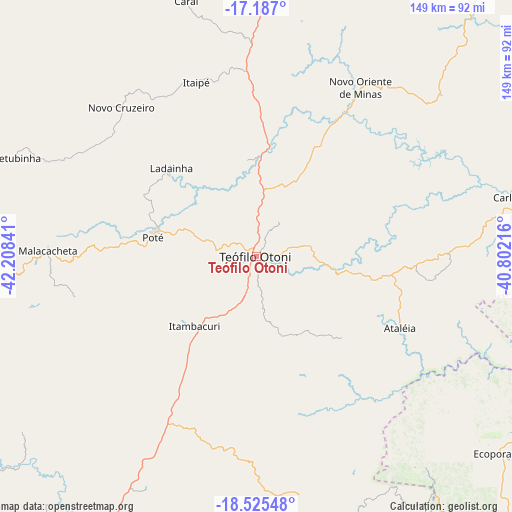
| Upper-left | -17.187°, | -42.20841° |
| Center: | -17.8575°, | -41.50528° |
| Lower-right: | -18.52548°, | -40.80216° |
| Map W x H: | 148.8×148.8 km | = 92.5×92.5mi |
| max Lat: | 2.81972° ⇑50.8% North |
| Teófilo Otoni: | -17.8575° |
| min Lat: | ⇓49.2% South -33.69111° |
| min Long | Teófilo Otoni | max Long |
| -72.89583° | -41.50528° | -32.41083° |
| W 68%⇐ | ⇒32% E |
Elevation
Elevation of Teófilo Otoni is 343 m = 1125 ft, and this is 37.9 m = 124 ft below average elevation for this country.
| Max E: |
1603 m = 5259 ft | 50.9% |
| Avg. | 380.9 m = 1250 ft | |
| Teófilo Otoni | 343 m = 1125 ft | |
Min E: |
0 m = 0 ft | 49.1% |
See also: Teófilo Otoni elevation on elevation.city.
Geographical zone
Teófilo Otoni is located in South Torrid zone (between Equator and Tropic of Capricorn). Distance of this Southern Tropic circle is 620.4 km =385.5 mi to South.| Distance of | km | miles | from Teófilo Otoni |
|---|---|---|---|
| Equator | 1985.6 | 1233.8 | to North |
| Tropic Capricorn | 620.4 | 385.5 | to South |
| Antarctic Circle | 5415.6 | 3365.1 | to South |
| South Pole | 8021.5 | 4984.3 | to South |


Nearby cities:
15 places around Teófilo Otoni: (largest is in red/bold)
• Barra de São Francisco
119 km =73.9 mi,  146°
146°
• Capelinha
108.6 km =67.5 mi,  279°
279°
• Caraí
77 km =47.8 mi,  344°
344°
• Carlos Chagas
80.1 km =49.8 mi,  77°
77°
• Divino das Laranjeiras
102.4 km =63.6 mi,  178°
178°
• Ecoporanga
91.5 km =56.9 mi,  128°
128°
• Governador Valadares
120 km =74.6 mi,  202°
202°
• Itambacuri
27.1 km =16.8 mi,  224°
224°
• Malacacheta
60.5 km =37.6 mi,  271°
271°
• Mantenópolis
118.8 km =73.8 mi,  160°
160°
• Mucurici
107.9 km =67 mi,  104°
104°
• Novo Cruzeiro
58.4 km =36.3 mi,  317°
317°
• Padre Paraíso
87.1 km =54.1 mi,  1°
1°
• Santa Maria do Suaçuí
103 km =64 mi,  248°
248°
• Águas Formosas
105.3 km =65.4 mi,  35°
35°
Sources, notices
• [Note1] Compared only with cities in Brazil existing in our database
• [Src1] Map data: © OpenStreetMap contributors (CC-BY-SA)
• [Src2] Other city data from geonames.org with taken over terms of usage.
• [Src3] Geographical zone / Annual Mean Temperature by Robert A. Rohde @ Wikipedia
