Padre Paraíso geodata
Padre Paraíso (Minas Gerais) is a populated place; located in Brazil in America/Sao_Paulo (GMT-3) time zone. With population of 10,608 people, there are 1594 cities with bigger population in this country. Compared to other cities in Brazil, 50.8% of cities are located further ↓South; 68.1% of cities are located further ←West and 79.5% of cities have lower elevation than Padre Paraíso. Note1


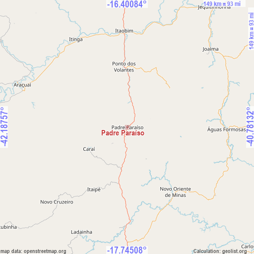
Padre Paraíso GPS coordinates[2]
17° 4' 27.012" South, 41° 29' 3.984" West
| Map corner | latitude | longitude |
|---|---|---|
| Upper-left | -16.40084°, | -42.18757° |
| Center: | -17.07417°, | -41.48444° |
| Lower-right: | -17.74508°, | -40.78132° |
| Map W x H: | 149.5×149.5 km | = 92.9×92.9mi |
| max Lat: | 2.81972° ⇑49.2% North |
| Padre Paraíso: | -17.07417° |
| min Lat: | ⇓50.8% South -33.69111° |
| min Long | Padre Paraíso | max Long |
| -72.89583° | -41.48444° | -32.41083° |
| W 68.1%⇐ | ⇒31.9% E |
Elevation
Elevation of Padre Paraíso is 681 m = 2234 ft, and this is 300.1 m = 985 ft above average elevation for this country.
| Max E: |
1603 m = 5259 ft | 20.5% |
| Padre Paraíso | 681 m 2234 ft | |
| Avg. | 380.9 m = 1250 ft | |
Min E: |
0 m = 0 ft | 79.5% |
See also: Brazil elevation on elevation.city.
Geographical zone
Padre Paraíso is located in South Torrid zone (between Equator and Tropic of Capricorn). Distance of this Southern Tropic circle is 707.4 km =439.6 mi to South.| Distance of | km | miles | from Padre Paraíso |
|---|---|---|---|
| Equator | 1898.5 | 1179.7 | to North |
| Tropic Capricorn | 707.4 | 439.6 | to South |
| Antarctic Circle | 5502.7 | 3419.2 | to South |
| South Pole | 8108.6 | 5038.4 | to South |


Nearby cities:
15 places around Padre Paraíso: (largest is in red/bold)
• Araçuaí
67.1 km =41.7 mi,  291°
291°
• Caraí
25.7 km =16 mi,  240°
240°
• Carlos Chagas
103.4 km =64.2 mi,  132°
132°
• Itambacuri
108.5 km =67.4 mi,  191°
191°
• Itanhém
123.1 km =76.5 mi,  94°
94°
• Itinga
59.3 km =36.8 mi,  329°
329°
• Jequitinhonha
87.7 km =54.5 mi,  35°
35°
• Joaíma
67.2 km =41.8 mi,  45°
45°
• Malacacheta
106 km =65.9 mi,  216°
216°
• Medina
94.7 km =58.8 mi,  0°
0°
• Minas Novas
118.6 km =73.7 mi,  262°
262°
• Novo Cruzeiro
60.3 km =37.5 mi, 223°
• Pedra Azul
120.5 km =74.9 mi,  9°
9°
• Teófilo Otoni
87.1 km =54.1 mi,  181°
181°
• Águas Formosas
58.3 km =36.2 mi, 90°
Sources, notices
• [Note1] Compared only with cities in Brazil existing in our database
• [Src1] Map data: © OpenStreetMap contributors (CC-BY-SA)
• [Src2] Other city data from geonames.org with taken over terms of usage.
• [Src3] Geographical zone / Annual Mean Temperature by Robert A. Rohde @ Wikipedia
