Malacacheta geodata
Malacacheta (Minas Gerais) is a populated place; located in Brazil in America/Sao_Paulo (GMT-3) time zone. With population of 8,819 people, there are 1732 cities with bigger population in this country. Compared to other cities in Brazil, 50.7% of cities are located further ↑North; 65.4% of cities are located further ←West and 79.6% of cities have lower elevation than Malacacheta. Note1


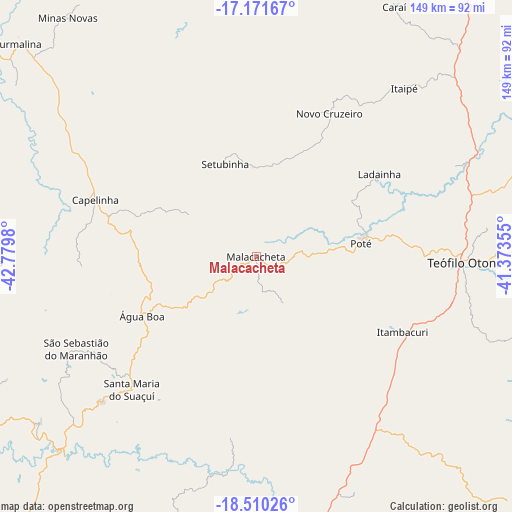
Malacacheta GPS coordinates[2]
17° 50' 31.992" South, 42° 4' 36.012" West
| Map corner | latitude | longitude |
|---|---|---|
| Upper-left | -17.17167°, | -42.7798° |
| Center: | -17.84222°, | -42.07667° |
| Lower-right: | -18.51026°, | -41.37355° |
| Map W x H: | 148.8×148.8 km | = 92.5×92.5mi |
| max Lat: | 2.81972° ⇑50.7% North |
| Malacacheta: | -17.84222° |
| min Lat: | ⇓49.3% South -33.69111° |
| min Long | Malacacheta | max Long |
| -72.89583° | -42.07667° | -32.41083° |
| W 65.4%⇐ | ⇒34.6% E |
Elevation
Elevation of Malacacheta is 683 m = 2241 ft, and this is 302.1 m = 991 ft above average elevation for this country.
| Max E: |
1603 m = 5259 ft | 20.4% |
| Malacacheta | 683 m 2241 ft | |
| Avg. | 380.9 m = 1250 ft | |
Min E: |
0 m = 0 ft | 79.6% |
See also: Brazil elevation on elevation.city.
Geographical zone
Malacacheta is located in South Torrid zone (between Equator and Tropic of Capricorn). Distance of this Southern Tropic circle is 622.1 km =386.6 mi to South.| Distance of | km | miles | from Malacacheta |
|---|---|---|---|
| Equator | 1983.9 | 1232.7 | to North |
| Tropic Capricorn | 622.1 | 386.6 | to South |
| Antarctic Circle | 5417.3 | 3366.2 | to South |
| South Pole | 8023.2 | 4985.4 | to South |


Nearby cities:
15 places around Malacacheta: (largest is in red/bold)
• Araçuaí
110.4 km =68.6 mi,  0°
0°
• Capelinha
49.4 km =30.7 mi,  289°
289°
• Caraí
83.2 km =51.7 mi,  29°
29°
• Divino das Laranjeiras
121.6 km =75.6 mi,  148°
148°
• Governador Valadares
113 km =70.2 mi,  173°
173°
• Itamarandiba
82.8 km =51.4 mi,  268°
268°
• Itambacuri
46.5 km =28.9 mi,  116°
116°
• Minas Novas
88.2 km =54.8 mi,  321°
321°
• Novo Cruzeiro
46.8 km =29.1 mi, 27°
• Padre Paraíso
106 km =65.9 mi,  36°
36°
• Peçanha
93.5 km =58.1 mi,  212°
212°
• Santa Maria do Suaçuí
52.6 km =32.7 mi,  222°
222°
• São João Evangelista
106.8 km =66.4 mi, 222°
• Teófilo Otoni
60.5 km =37.6 mi,  91°
91°
• Turmalina
92.9 km =57.7 mi,  311°
311°
Sources, notices
• [Note1] Compared only with cities in Brazil existing in our database
• [Src1] Map data: © OpenStreetMap contributors (CC-BY-SA)
• [Src2] Other city data from geonames.org with taken over terms of usage.
• [Src3] Geographical zone / Annual Mean Temperature by Robert A. Rohde @ Wikipedia
