Carlos Chagas geodata
Carlos Chagas (Minas Gerais) is a populated place; located in Brazil in America/Sao_Paulo (GMT-3) time zone. With population of 13,206 people, there are 1356 cities with bigger population in this country. Compared to other cities in Brazil, 50.3% of cities are located further ↑North; 71.2% of cities are located further ←West and 60.5% of cities have higher elevation than Carlos Chagas. Note1


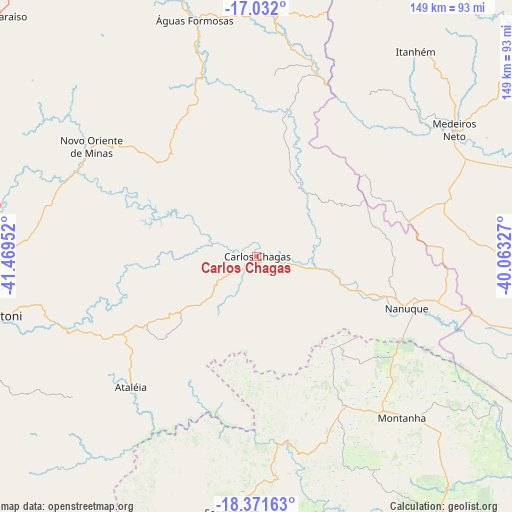
Carlos Chagas GPS coordinates[2]
17° 42' 11.016" South, 40° 45' 59.004" West
| Map corner | latitude | longitude |
|---|---|---|
| Upper-left | -17.032°, | -41.46952° |
| Center: | -17.70306°, | -40.76639° |
| Lower-right: | -18.37163°, | -40.06327° |
| Map W x H: | 149×149 km | = 92.6×92.6mi |
| max Lat: | 2.81972° ⇑50.3% North |
| Carlos Chagas: | -17.70306° |
| min Lat: | ⇓49.7% South -33.69111° |
| min Long | Carlos Chagas | max Long |
| -72.89583° | -40.76639° | -32.41083° |
| W 71.2%⇐ | ⇒28.8% E |
Elevation
Elevation of Carlos Chagas is 206 m = 676 ft, and this is 174.9 m = 574 ft below average elevation for this country.
| Max E: |
1603 m = 5259 ft | 60.5% |
| Avg. | 380.9 m = 1250 ft | |
| Carlos Chagas | 206 m = 676 ft | |
Min E: |
0 m = 0 ft | 39.5% |
See also: Brazil elevation on elevation.city.
Geographical zone
Carlos Chagas is located in South Torrid zone (between Equator and Tropic of Capricorn). Distance of this Southern Tropic circle is 637.5 km =396.1 mi to South.| Distance of | km | miles | from Carlos Chagas |
|---|---|---|---|
| Equator | 1968.4 | 1223.1 | to North |
| Tropic Capricorn | 637.5 | 396.1 | to South |
| Antarctic Circle | 5432.8 | 3375.8 | to South |
| South Pole | 8038.7 | 4995 | to South |


Nearby cities:
15 places around Carlos Chagas: (largest is in red/bold)
• Barra de São Francisco
117.7 km =73.1 mi,  186°
186°
• Boa Esperança
105.5 km =65.6 mi,  151°
151°
• Caraí
113.9 km =70.8 mi,  300°
300°
• Ecoporanga
74.8 km =46.5 mi, 185°
• Itambacuri
103.8 km =64.5 mi,  249°
249°
• Itanhém
75.5 km =46.9 mi,  37°
37°
• Medeiros Neto
68.5 km =42.6 mi,  57°
57°
• Montanha
63.6 km =39.5 mi,  137°
137°
• Mucurici
50.9 km =31.6 mi, 148°
• Nanuque
46.2 km =28.7 mi,  109°
109°
• Padre Paraíso
103.4 km =64.2 mi,  312°
312°
• Posto da Mata
98.6 km =61.3 mi,  102°
102°
• Teixeira de Freitas
110.2 km =68.5 mi,  80°
80°
• Teófilo Otoni
80.1 km =49.8 mi,  257°
257°
• Águas Formosas
71.3 km =44.3 mi,  345°
345°
Sources, notices
• [Note1] Compared only with cities in Brazil existing in our database
• [Src1] Map data: © OpenStreetMap contributors (CC-BY-SA)
• [Src2] Other city data from geonames.org with taken over terms of usage.
• [Src3] Geographical zone / Annual Mean Temperature by Robert A. Rohde @ Wikipedia
