Ecoporanga geodata
Ecoporanga (Espírito Santo) is a populated place; located in Brazil in America/Sao_Paulo (GMT-3) time zone. With population of 13,774 people, there are 1310 cities with bigger population in this country. Compared to other cities in Brazil, 51.5% of cities are located further ↑North; 70.9% of cities are located further ←West and 58.2% of cities have higher elevation than Ecoporanga. Note1


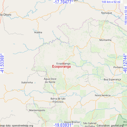
Ecoporanga GPS coordinates[2]
18° 22' 23.988" South, 40° 49' 50.016" West
| Map corner | latitude | longitude |
|---|---|---|
| Upper-left | -17.70477°, | -41.53369° |
| Center: | -18.37333°, | -40.83056° |
| Lower-right: | -19.03931°, | -40.12744° |
| Map W x H: | 148.4×148.4 km | = 92.2×92.2mi |
| max Lat: | 2.81972° ⇑51.5% North |
| Ecoporanga: | -18.37333° |
| min Lat: | ⇓48.5% South -33.69111° |
| min Long | Ecoporanga | max Long |
| -72.89583° | -40.83056° | -32.41083° |
| W 70.9%⇐ | ⇒29.1% E |
Elevation
Elevation of Ecoporanga is 230 m = 755 ft, and this is 150.9 m = 495 ft below average elevation for this country.
| Max E: |
1603 m = 5259 ft | 58.2% |
| Avg. | 380.9 m = 1250 ft | |
| Ecoporanga | 230 m = 755 ft | |
Min E: |
0 m = 0 ft | 41.8% |
See also: Brazil elevation on elevation.city.
Geographical zone
Ecoporanga is located in South Torrid zone (between Equator and Tropic of Capricorn). Distance of this Southern Tropic circle is 563 km =349.8 mi to South.| Distance of | km | miles | from Ecoporanga |
|---|---|---|---|
| Equator | 2042.9 | 1269.4 | to North |
| Tropic Capricorn | 563 | 349.8 | to South |
| Antarctic Circle | 5358.3 | 3329.5 | to South |
| South Pole | 7964.1 | 4948.7 | to South |


Nearby cities:
15 places around Ecoporanga: (largest is in red/bold)
• Barra de São Francisco
42.9 km =26.7 mi,  188°
188°
• Boa Esperança
59.4 km =36.9 mi,  108°
108°
• Carlos Chagas
74.8 km =46.5 mi,  5°
5°
• Conselheiro Pena
111.6 km =69.3 mi,  217°
217°
• Divino das Laranjeiras
81.9 km =50.9 mi,  236°
236°
• Itambacuri
97.9 km =60.8 mi,  292°
292°
• Mantenópolis
62.5 km =38.8 mi,  209°
209°
• Montanha
56.4 km =35 mi,  60°
60°
• Mucurici
45.5 km =28.3 mi,  46°
46°
• Nanuque
77.9 km =48.4 mi,  40°
40°
• Nova Venécia
58.8 km =36.5 mi,  129°
129°
• Pancas
94.7 km =58.8 mi,  181°
181°
• São Mateus
109.4 km =68 mi, 110°
• Teófilo Otoni
91.5 km =56.9 mi,  308°
308°
• Águia Branca
68.5 km =42.6 mi,  172°
172°
Sources, notices
• [Note1] Compared only with cities in Brazil existing in our database
• [Src1] Map data: © OpenStreetMap contributors (CC-BY-SA)
• [Src2] Other city data from geonames.org with taken over terms of usage.
• [Src3] Geographical zone / Annual Mean Temperature by Robert A. Rohde @ Wikipedia
