Águas Formosas geodata
Águas Formosas (Minas Gerais) is a populated place; located in Brazil in America/Sao_Paulo (GMT-3) time zone. With population of 11,511 people, there are 1522 cities with bigger population in this country. Compared to other cities in Brazil, 50.8% of cities are located further ↓South; 70.3% of cities are located further ←West and 55.7% of cities have higher elevation than Águas Formosas. Note1


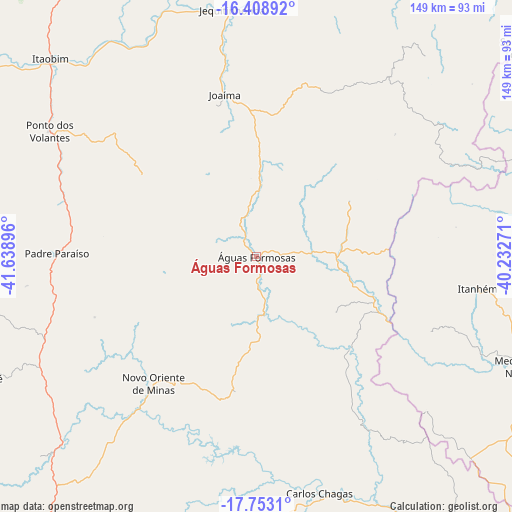
Águas Formosas GPS coordinates[2]
17° 4' 55.992" South, 40° 56' 8.988" West
| Map corner | latitude | longitude |
|---|---|---|
| Upper-left | -16.40892°, | -41.63896° |
| Center: | -17.08222°, | -40.93583° |
| Lower-right: | -17.7531°, | -40.23271° |
| Map W x H: | 149.5×149.5 km | = 92.9×92.9mi |
| max Lat: | 2.81972° ⇑49.2% North |
| Águas Formosas: | -17.08222° |
| min Lat: | ⇓50.8% South -33.69111° |
| min Long | Águas Formosas | max Long |
| -72.89583° | -40.93583° | -32.41083° |
| W 70.3%⇐ | ⇒29.7% E |
Elevation
Elevation of Águas Formosas is 260 m = 853 ft, and this is 120.9 m = 397 ft below average elevation for this country.
| Max E: |
1603 m = 5259 ft | 55.7% |
| Avg. | 380.9 m = 1250 ft | |
| Águas Formosas | 260 m = 853 ft | |
Min E: |
0 m = 0 ft | 44.3% |
See also: Brazil elevation on elevation.city.
Geographical zone
Águas Formosas is located in South Torrid zone (between Equator and Tropic of Capricorn). Distance of this Southern Tropic circle is 706.6 km =439.1 mi to South.| Distance of | km | miles | from Águas Formosas |
|---|---|---|---|
| Equator | 1899.4 | 1180.2 | to North |
| Tropic Capricorn | 706.6 | 439.1 | to South |
| Antarctic Circle | 5501.8 | 3418.7 | to South |
| South Pole | 8107.7 | 5037.9 | to South |


Nearby cities:
15 places around Águas Formosas: (largest is in red/bold)
• Almenara
103.2 km =64.1 mi,  14°
14°
• Araçuaí
123.4 km =76.7 mi,  282°
282°
• Caraí
81.5 km =50.6 mi,  261°
261°
• Carlos Chagas
71.3 km =44.3 mi,  165°
165°
• Itanhém
65.1 km =40.5 mi,  98°
98°
• Itinga
102.5 km =63.7 mi,  300°
300°
• Jequitinhonha
72.4 km =45 mi,  354°
354°
• Joaíma
48.7 km =30.3 mi, 348°
• Medeiros Neto
82.6 km =51.3 mi,  113°
113°
• Medina
111.6 km =69.3 mi,  328°
328°
• Mucurici
120.9 km =75.1 mi,  158°
158°
• Nanuque
104.4 km =64.9 mi,  143°
143°
• Novo Cruzeiro
108.6 km =67.5 mi,  246°
246°
• Padre Paraíso
58.3 km =36.2 mi,  270°
270°
• Teófilo Otoni
105.3 km =65.4 mi,  215°
215°
Sources, notices
• [Note1] Compared only with cities in Brazil existing in our database
• [Src1] Map data: © OpenStreetMap contributors (CC-BY-SA)
• [Src2] Other city data from geonames.org with taken over terms of usage.
• [Src3] Geographical zone / Annual Mean Temperature by Robert A. Rohde @ Wikipedia
