Luziânia geodata
Luziânia (Goiás) is a populated place; located in Brazil in America/Sao_Paulo (GMT-3) time zone. With population of 143,601 people, there are 159 cities with bigger population in this country. Compared to other cities in Brazil, 52.9% of cities are located further ↓South; 64.4% of cities are located further →East and 96.8% of cities have lower elevation than Luziânia. Note1


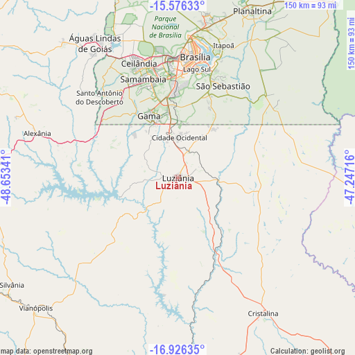
Luziânia GPS coordinates[2]
16° 15' 9" South, 47° 57' 1.008" West
| Map corner | latitude | longitude |
|---|---|---|
| Upper-left | -15.57633°, | -48.65341° |
| Center: | -16.2525°, | -47.95028° |
| Lower-right: | -16.92635°, | -47.24716° |
| Map W x H: | 150.1×150.1 km | = 93.3×93.3mi |
| max Lat: | 2.81972° ⇑47.1% North |
| Luziânia: | -16.2525° |
| min Lat: | ⇓52.9% South -33.69111° |
| min Long | Luziânia | max Long |
| -72.89583° | -47.95028° | -32.41083° |
| W 35.6%⇐ | ⇒64.4% E |
Elevation
Elevation of Luziânia is 932 m = 3058 ft, and this is 551.1 m = 1808 ft above average elevation for this country.
| Max E: |
1603 m = 5259 ft | 3.2% |
| Luziânia | 932 m 3058 ft | |
| Avg. | 380.9 m = 1250 ft | |
Min E: |
0 m = 0 ft | 96.8% |
See also: Luziânia elevation on elevation.city.
Geographical zone
Luziânia is located in South Torrid zone (between Equator and Tropic of Capricorn). Distance of this Southern Tropic circle is 798.8 km =496.4 mi to South.| Distance of | km | miles | from Luziânia |
|---|---|---|---|
| Equator | 1807.1 | 1122.9 | to North |
| Tropic Capricorn | 798.8 | 496.4 | to South |
| Antarctic Circle | 5594.1 | 3476 | to South |
| South Pole | 8200 | 5095.2 | to South |


Nearby cities:
15 places around Luziânia: (largest is in red/bold)
• Abadiânia
81 km =50.3 mi,  273°
273°
• Anápolis
107.3 km =66.7 mi, 265°
• Brasília
52.6 km =32.7 mi,  2°
2°
• Cristalina
67.5 km =41.9 mi,  148°
148°
• Formosa
103.3 km =64.2 mi,  39°
39°
• Goianápolis
118.1 km =73.4 mi,  255°
255°
• Orizona
94.1 km =58.5 mi,  203°
203°
• Padre Bernardo
125.9 km =78.2 mi,  343°
343°
• Pirenópolis
116.9 km =72.6 mi,  292°
292°
• Pires do Rio
121.6 km =75.6 mi, 196°
• Planaltina
77.6 km =48.2 mi,  24°
24°
• Planaltina
95.9 km =59.6 mi, 22°
• Silvânia
83.4 km =51.8 mi,  237°
237°
• Unaí
112 km =69.6 mi,  95°
95°
• Vianópolis
81.3 km =50.5 mi,  227°
227°
Sources, notices
• [Note1] Compared only with cities in Brazil existing in our database
• [Src1] Map data: © OpenStreetMap contributors (CC-BY-SA)
• [Src2] Other city data from geonames.org with taken over terms of usage.
• [Src3] Geographical zone / Annual Mean Temperature by Robert A. Rohde @ Wikipedia
