São Sebastião geodata
São Sebastião (São Paulo) is a seat of a second-order administrative division; located in Brazil in America/Sao_Paulo (GMT-3) time zone. With population of 76,367 people, there are 301 cities with bigger population in this country. Compared to other cities in Brazil, 84.8% of cities are located further ↑North; 50.6% of cities are located further →East and 98.3% of cities have higher elevation than São Sebastião. Note1


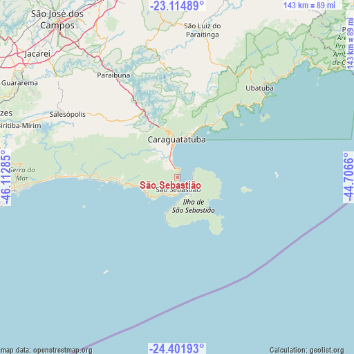
São Sebastião GPS coordinates[2]
23° 45' 36" South, 45° 24' 34.992" West
| Map corner | latitude | longitude |
|---|---|---|
| Upper-left | -23.11489°, | -46.11285° |
| Center: | -23.76°, | -45.40972° |
| Lower-right: | -24.40193°, | -44.7066° |
| Map W x H: | 143.1×143.1 km | = 88.9×88.9mi |
| max Lat: | 2.81972° ⇑84.8% North |
| São Sebastião: | -23.76° |
| min Lat: | ⇓15.2% South -33.69111° |
| min Long | São Sebastião | max Long |
| -72.89583° | -45.40972° | -32.41083° |
| W 49.4%⇐ | ⇒50.6% E |
Elevation
Elevation of São Sebastião is 6 m = 20 ft, and this is 374.9 m = 1230 ft below average elevation for this country.
| Max E: |
1603 m = 5259 ft | 98.3% |
| Avg. | 380.9 m = 1250 ft | |
| São Sebastião | 6 m = 20 ft | |
Min E: |
0 m = 0 ft | 1.7% |
See also: São Sebastião elevation on elevation.city.
Geographical zone
São Sebastião is located in South temperate zone (between Tropic of Capricorn and the Antarctic Circle). Distance of this Southern Tropic circle is 35.9 km =22.3 mi to North.| Distance of | km | miles | from São Sebastião |
|---|---|---|---|
| Equator | 2641.9 | 1641.6 | to North |
| Tropic Capricorn | 35.9 | 22.3 | to North |
| Antarctic Circle | 4759.3 | 2957.3 | to South |
| South Pole | 7365.2 | 4576.5 | to South |


Nearby cities:
15 places around São Sebastião: (largest is in red/bold)
• Bertioga
74.9 km =46.5 mi,  261°
261°
• Biritiba Mirim
67.4 km =41.9 mi,  288°
288°
• Caraguatatuba
15.5 km =9.6 mi,  358°
358°
• Caçapava
79.3 km =49.3 mi,  337°
337°
• Cunha
89 km =55.3 mi,  31°
31°
• Guararema
74.4 km =46.2 mi,  301°
301°
• Guarujá
89.9 km =55.9 mi,  253°
253°
• Ilhabela
5.6 km =3.5 mi,  110°
110°
• Jacareí
76 km =47.2 mi,  311°
311°
• Mogi das Cruzes
83.6 km =51.9 mi, 288°
• Santa Branca
63 km =39.1 mi, 309°
• São José dos Campos
80.8 km =50.2 mi,  322°
322°
• Taubaté
82.9 km =51.5 mi,  349°
349°
• Tremembé
90.3 km =56.1 mi, 350°
• Ubatuba
50.1 km =31.1 mi,  43°
43°
Sources, notices
• [Note1] Compared only with cities in Brazil existing in our database
• [Src1] Map data: © OpenStreetMap contributors (CC-BY-SA)
• [Src2] Other city data from geonames.org with taken over terms of usage.
• [Src3] Geographical zone / Annual Mean Temperature by Robert A. Rohde @ Wikipedia
