Taubaté geodata
Taubaté (São Paulo) is a seat of a second-order administrative division; located in Brazil in America/Sao_Paulo (GMT-3) time zone. With population of 251,641 people, there are 88 cities with bigger population in this country. Compared to other cities in Brazil, 78.8% of cities are located further ↑North; 51.2% of cities are located further →East and 71.7% of cities have lower elevation than Taubaté. Note1


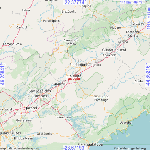
Taubaté GPS coordinates[2]
23° 1' 35.004" South, 45° 33' 19.008" West
| Map corner | latitude | longitude |
|---|---|---|
| Upper-left | -22.37774°, | -46.25841° |
| Center: | -23.02639°, | -45.55528° |
| Lower-right: | -23.67193°, | -44.85216° |
| Map W x H: | 143.9×143.9 km | = 89.4×89.4mi |
| max Lat: | 2.81972° ⇑78.8% North |
| Taubaté: | -23.02639° |
| min Lat: | ⇓21.2% South -33.69111° |
| min Long | Taubaté | max Long |
| -72.89583° | -45.55528° | -32.41083° |
| W 48.8%⇐ | ⇒51.2% E |
Elevation
Elevation of Taubaté is 589 m = 1932 ft, and this is 208.1 m = 683 ft above average elevation for this country.
| Max E: |
1603 m = 5259 ft | 28.3% |
| Taubaté | 589 m 1932 ft | |
| Avg. | 380.9 m = 1250 ft | |
Min E: |
0 m = 0 ft | 71.7% |
See also: Taubaté elevation on elevation.city.
Geographical zone
Taubaté is located in South Torrid zone (between Equator and Tropic of Capricorn). Distance of this Southern Tropic circle is 45.6 km =28.3 mi to South.| Distance of | km | miles | from Taubaté |
|---|---|---|---|
| Equator | 2560.3 | 1590.9 | to North |
| Tropic Capricorn | 45.6 | 28.3 | to South |
| Antarctic Circle | 4840.9 | 3008 | to South |
| South Pole | 7446.8 | 4627.2 | to South |


Nearby cities:
15 places around Taubaté: (largest is in red/bold)
• Aparecida
38.9 km =24.2 mi,  59°
59°
• Campos do Jordão
32.1 km =19.9 mi,  353°
353°
• Caçapava
17.6 km =10.9 mi,  241°
241°
• Cunha
61.2 km =38 mi,  95°
95°
• Guararema
65.3 km =40.6 mi,  228°
228°
• Guaratinguetá
43.9 km =27.3 mi, 57°
• Jacareí
52.2 km =32.4 mi, 233°
• Lorena
55 km =34.2 mi,  53°
53°
• Monte Verde
52.3 km =32.5 mi,  290°
290°
• Paraisópolis
57.3 km =35.6 mi,  336°
336°
• Pindamonhangaba
14.9 km =9.3 mi,  40°
40°
• Piquete
60.1 km =37.3 mi, 40°
• Santa Branca
53.1 km =33 mi,  219°
219°
• São José dos Campos
37.9 km =23.5 mi, 243°
• Tremembé
7.6 km =4.7 mi,  4°
4°
Sources, notices
• [Note1] Compared only with cities in Brazil existing in our database
• [Src1] Map data: © OpenStreetMap contributors (CC-BY-SA)
• [Src2] Other city data from geonames.org with taken over terms of usage.
• [Src3] Geographical zone / Annual Mean Temperature by Robert A. Rohde @ Wikipedia
