Ilhabela geodata
Ilhabela (São Paulo) is a seat of a second-order administrative division; located in Brazil in America/Sao_Paulo (GMT-3) time zone. With population of 32,892 people, there are 622 cities with bigger population in this country. Compared to other cities in Brazil, 84.9% of cities are located further ↑North; 50.4% of cities are located further →East and 97.2% of cities have higher elevation than Ilhabela. Note1


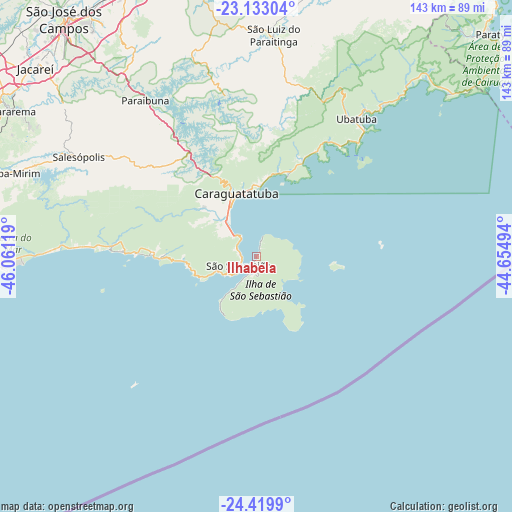
Ilhabela GPS coordinates[2]
23° 46' 41.016" South, 45° 21' 29.016" West
| Map corner | latitude | longitude |
|---|---|---|
| Upper-left | -23.13304°, | -46.06119° |
| Center: | -23.77806°, | -45.35806° |
| Lower-right: | -24.4199°, | -44.65494° |
| Map W x H: | 143.1×143.1 km | = 88.9×88.9mi |
| max Lat: | 2.81972° ⇑84.9% North |
| Ilhabela: | -23.77806° |
| min Lat: | ⇓15.1% South -33.69111° |
| min Long | Ilhabela | max Long |
| -72.89583° | -45.35806° | -32.41083° |
| W 49.6%⇐ | ⇒50.4% E |
Elevation
Elevation of Ilhabela is 7 m = 23 ft, and this is 373.9 m = 1227 ft below average elevation for this country.
| Max E: |
1603 m = 5259 ft | 97.2% |
| Avg. | 380.9 m = 1250 ft | |
| Ilhabela | 7 m = 23 ft | |
Min E: |
0 m = 0 ft | 2.8% |
See also: Brazil elevation on elevation.city.
Geographical zone
Ilhabela is located in South temperate zone (between Tropic of Capricorn and the Antarctic Circle). Distance of this Southern Tropic circle is 38 km =23.6 mi to North.| Distance of | km | miles | from Ilhabela |
|---|---|---|---|
| Equator | 2643.9 | 1642.8 | to North |
| Tropic Capricorn | 38 | 23.6 | to North |
| Antarctic Circle | 4757.3 | 2956 | to South |
| South Pole | 7363.2 | 4575.3 | to South |


Nearby cities:
15 places around Ilhabela: (largest is in red/bold)
• Bertioga
79.9 km =49.6 mi,  263°
263°
• Biritiba Mirim
73 km =45.4 mi,  288°
288°
• Caraguatatuba
18.4 km =11.4 mi,  342°
342°
• Caçapava
83.3 km =51.8 mi,  334°
334°
• Cunha
88.2 km =54.8 mi,  27°
27°
• Guararema
79.9 km =49.6 mi,  300°
300°
• Jacareí
81.3 km =50.5 mi,  310°
310°
• Mogi das Cruzes
89.2 km =55.4 mi, 288°
• Paraty
90.6 km =56.3 mi,  46°
46°
• Santa Branca
68.3 km =42.4 mi, 308°
• São José dos Campos
85.7 km =53.3 mi,  320°
320°
• São Sebastião
5.6 km =3.5 mi, 290°
• Taubaté
86 km =53.4 mi,  346°
346°
• Tremembé
93.2 km =57.9 mi, 347°
• Ubatuba
48.2 km =30 mi,  37°
37°
Sources, notices
• [Note1] Compared only with cities in Brazil existing in our database
• [Src1] Map data: © OpenStreetMap contributors (CC-BY-SA)
• [Src2] Other city data from geonames.org with taken over terms of usage.
• [Src3] Geographical zone / Annual Mean Temperature by Robert A. Rohde @ Wikipedia
