Tremembé geodata
Tremembé (São Paulo) is a populated place; located in Brazil in America/Sao_Paulo (GMT-3) time zone. With population of 31,719 people, there are 641 cities with bigger population in this country. Compared to other cities in Brazil, 78.2% of cities are located further ↑North; 51.2% of cities are located further →East and 68% of cities have lower elevation than Tremembé. Note1


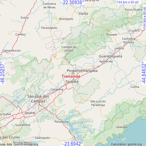
Tremembé GPS coordinates[2]
22° 57' 29.988" South, 45° 32' 57.984" West
| Map corner | latitude | longitude |
|---|---|---|
| Upper-left | -22.30936°, | -46.25257° |
| Center: | -22.95833°, | -45.54944° |
| Lower-right: | -23.6042°, | -44.84632° |
| Map W x H: | 144×144 km | = 89.5×89.5mi |
| max Lat: | 2.81972° ⇑78.2% North |
| Tremembé: | -22.95833° |
| min Lat: | ⇓21.8% South -33.69111° |
| min Long | Tremembé | max Long |
| -72.89583° | -45.54944° | -32.41083° |
| W 48.8%⇐ | ⇒51.2% E |
Elevation
Elevation of Tremembé is 558 m = 1831 ft, and this is 177.1 m = 581 ft above average elevation for this country.
| Max E: |
1603 m = 5259 ft | 32% |
| Tremembé | 558 m 1831 ft | |
| Avg. | 380.9 m = 1250 ft | |
Min E: |
0 m = 0 ft | 68% |
See also: Brazil elevation on elevation.city.
Geographical zone
Tremembé is located in South Torrid zone (between Equator and Tropic of Capricorn). Distance of this Southern Tropic circle is 53.2 km =33.1 mi to South.| Distance of | km | miles | from Tremembé |
|---|---|---|---|
| Equator | 2552.7 | 1586.2 | to North |
| Tropic Capricorn | 53.2 | 33.1 | to South |
| Antarctic Circle | 4848.4 | 3012.7 | to South |
| South Pole | 7454.3 | 4631.9 | to South |


Nearby cities:
15 places around Tremembé: (largest is in red/bold)
• Aparecida
35 km =21.7 mi,  69°
69°
• Campos do Jordão
24.7 km =15.3 mi,  349°
349°
• Caçapava
22.6 km =14 mi,  225°
225°
• Cunha
61.7 km =38.3 mi,  102°
102°
• Guaratinguetá
39.8 km =24.7 mi, 66°
• Itajubá
60.1 km =37.3 mi,  9°
9°
• Jacareí
57.5 km =35.7 mi, 227°
• Lorena
50.3 km =31.3 mi,  59°
59°
• Monte Verde
50.8 km =31.6 mi,  281°
281°
• Paraisópolis
50.8 km =31.6 mi,  332°
332°
• Pindamonhangaba
9.8 km =6.1 mi, 66°
• Piquete
54.2 km =33.7 mi,  44°
44°
• Santa Branca
59.5 km =37 mi,  215°
215°
• São José dos Campos
42.4 km =26.3 mi, 234°
• Taubaté
7.6 km =4.7 mi,  184°
184°
Sources, notices
• [Note1] Compared only with cities in Brazil existing in our database
• [Src1] Map data: © OpenStreetMap contributors (CC-BY-SA)
• [Src2] Other city data from geonames.org with taken over terms of usage.
• [Src3] Geographical zone / Annual Mean Temperature by Robert A. Rohde @ Wikipedia
