Caçapava geodata
Caçapava (São Paulo) is a populated place; located in Brazil in America/Sao_Paulo (GMT-3) time zone. With population of 72,340 people, there are 313 cities with bigger population in this country. Compared to other cities in Brazil, 79.6% of cities are located further ↑North; 51.7% of cities are located further →East and 68.8% of cities have lower elevation than Caçapava. Note1


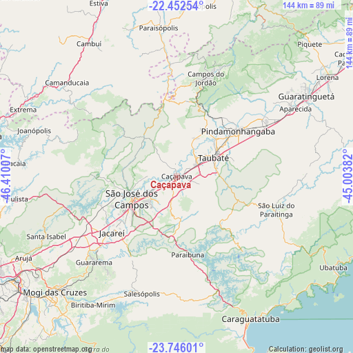
Caçapava GPS coordinates[2]
23° 6' 2.988" South, 45° 42' 24.984" West
| Map corner | latitude | longitude |
|---|---|---|
| Upper-left | -22.45254°, | -46.41007° |
| Center: | -23.10083°, | -45.70694° |
| Lower-right: | -23.74601°, | -45.00382° |
| Map W x H: | 143.8×143.8 km | = 89.4×89.4mi |
| max Lat: | 2.81972° ⇑79.6% North |
| Caçapava: | -23.10083° |
| min Lat: | ⇓20.4% South -33.69111° |
| min Long | Caçapava | max Long |
| -72.89583° | -45.70694° | -32.41083° |
| W 48.3%⇐ | ⇒51.7% E |
Elevation
Elevation of Caçapava is 564 m = 1850 ft, and this is 183.1 m = 601 ft above average elevation for this country.
| Max E: |
1603 m = 5259 ft | 31.2% |
| Caçapava | 564 m 1850 ft | |
| Avg. | 380.9 m = 1250 ft | |
Min E: |
0 m = 0 ft | 68.8% |
See also: Caçapava elevation on elevation.city.
Geographical zone
Caçapava is located in South Torrid zone (between Equator and Tropic of Capricorn). Distance of this Southern Tropic circle is 37.3 km =23.2 mi to South.| Distance of | km | miles | from Caçapava |
|---|---|---|---|
| Equator | 2568.6 | 1596.1 | to North |
| Tropic Capricorn | 37.3 | 23.2 | to South |
| Antarctic Circle | 4832.6 | 3002.8 | to South |
| South Pole | 7438.5 | 4622.1 | to South |


Nearby cities:
15 places around Caçapava: (largest is in red/bold)
• Aparecida
56.4 km =35 mi,  59°
59°
• Camanducaia
59 km =36.7 mi,  310°
310°
• Campos do Jordão
41.9 km =26 mi,  16°
16°
• Guararema
48.4 km =30.1 mi,  223°
223°
• Guaratinguetá
61.4 km =38.2 mi, 59°
• Jacareí
34.9 km =21.7 mi,  229°
229°
• Joanópolis
61.2 km =38 mi,  288°
288°
• Monte Verde
42.7 km =26.5 mi, 308°
• Paraisópolis
61.2 km =38 mi,  352°
352°
• Pindamonhangaba
31.9 km =19.8 mi,  51°
51°
• Santa Branca
37.5 km =23.3 mi,  208°
208°
• Santa Isabel
57.7 km =35.9 mi,  245°
245°
• São José dos Campos
20.4 km =12.7 mi,  244°
244°
• Taubaté
17.6 km =10.9 mi, 61°
• Tremembé
22.6 km =14 mi, 45°
Sources, notices
• [Note1] Compared only with cities in Brazil existing in our database
• [Src1] Map data: © OpenStreetMap contributors (CC-BY-SA)
• [Src2] Other city data from geonames.org with taken over terms of usage.
• [Src3] Geographical zone / Annual Mean Temperature by Robert A. Rohde @ Wikipedia
