Paramirim geodata
Paramirim (Bahia) is a populated place; located in Brazil in America/Bahia (GMT-3) time zone. With population of 7,421 people, there are 1806 cities with bigger population in this country. Compared to other cities in Brazil, 59.1% of cities are located further ↓South; 64.7% of cities are located further ←West and 73.8% of cities have lower elevation than Paramirim. Note1


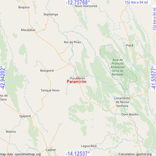
Paramirim GPS coordinates[2]
13° 26' 33" South, 42° 14' 20.004" West
| Map corner | latitude | longitude |
|---|---|---|
| Upper-left | -12.75768°, | -42.94202° |
| Center: | -13.4425°, | -42.23889° |
| Lower-right: | -14.12537°, | -41.53577° |
| Map W x H: | 152.1×152.1 km | = 94.5×94.5mi |
| max Lat: | 2.81972° ⇑40.9% North |
| Paramirim: | -13.4425° |
| min Lat: | ⇓59.1% South -33.69111° |
| min Long | Paramirim | max Long |
| -72.89583° | -42.23889° | -32.41083° |
| W 64.7%⇐ | ⇒35.3% E |
Elevation
Elevation of Paramirim is 611 m = 2005 ft, and this is 230.1 m = 755 ft above average elevation for this country.
| Max E: |
1603 m = 5259 ft | 26.2% |
| Paramirim | 611 m 2005 ft | |
| Avg. | 380.9 m = 1250 ft | |
Min E: |
0 m = 0 ft | 73.8% |
See also: Brazil elevation on elevation.city.
Geographical zone
Paramirim is located in South Torrid zone (between Equator and Tropic of Capricorn). Distance of this Southern Tropic circle is 1111.3 km =690.5 mi to South.| Distance of | km | miles | from Paramirim |
|---|---|---|---|
| Equator | 1494.7 | 928.8 | to North |
| Tropic Capricorn | 1111.3 | 690.5 | to South |
| Antarctic Circle | 5906.5 | 3670.1 | to South |
| South Pole | 8512.4 | 5289.4 | to South |


Nearby cities:
15 places around Paramirim: (largest is in red/bold)
• Barra da Estiva
100.7 km =62.6 mi,  101°
101°
• Bom Jesus da Lapa
129.3 km =80.3 mi,  279°
279°
• Boquira
87.1 km =54.1 mi,  322°
322°
• Brumado
104.9 km =65.2 mi,  143°
143°
• Caculé
118 km =73.3 mi,  179°
179°
• Caetité
74.2 km =46.1 mi,  200°
200°
• Guanambi
104.7 km =65.1 mi,  214°
214°
• Ituaçu
109.8 km =68.2 mi,  112°
112°
• Livramento do Brumado
48.4 km =30.1 mi,  118°
118°
• Macaúbas
68.5 km =42.6 mi,  313°
313°
• Paratinga
132.2 km =82.1 mi, 309°
• Riacho de Santana
77.9 km =48.4 mi,  256°
256°
• Santana
123.3 km =76.6 mi,  157°
157°
• Seabra
124.8 km =77.5 mi,  23°
23°
• Tanhaçu
124.9 km =77.6 mi, 121°
Sources, notices
• [Note1] Compared only with cities in Brazil existing in our database
• [Src1] Map data: © OpenStreetMap contributors (CC-BY-SA)
• [Src2] Other city data from geonames.org with taken over terms of usage.
• [Src3] Geographical zone / Annual Mean Temperature by Robert A. Rohde @ Wikipedia
