Caculé geodata
Caculé (Bahia) is a populated place; located in Brazil in America/Bahia (GMT-3) time zone. With population of 12,143 people, there are 1464 cities with bigger population in this country. Compared to other cities in Brazil, 57.2% of cities are located further ↓South; 64.9% of cities are located further ←West and 71.1% of cities have lower elevation than Caculé. Note1


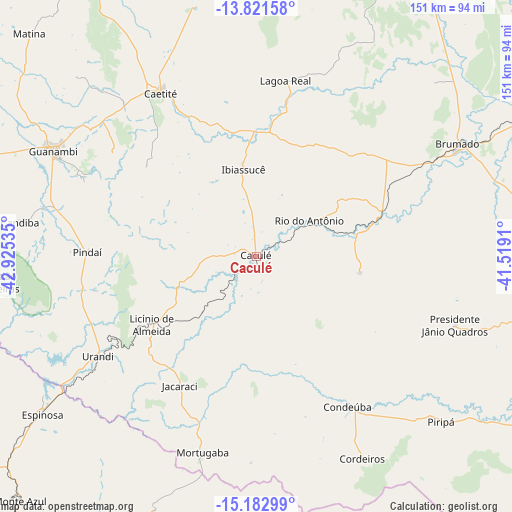
Caculé GPS coordinates[2]
14° 30' 11.988" South, 42° 13' 19.992" West
| Map corner | latitude | longitude |
|---|---|---|
| Upper-left | -13.82158°, | -42.92535° |
| Center: | -14.50333°, | -42.22222° |
| Lower-right: | -15.18299°, | -41.5191° |
| Map W x H: | 151.4×151.4 km | = 94.1×94.1mi |
| max Lat: | 2.81972° ⇑42.8% North |
| Caculé: | -14.50333° |
| min Lat: | ⇓57.2% South -33.69111° |
| min Long | Caculé | max Long |
| -72.89583° | -42.22222° | -32.41083° |
| W 64.9%⇐ | ⇒35.1% E |
Elevation
Elevation of Caculé is 584 m = 1916 ft, and this is 203.1 m = 666 ft above average elevation for this country.
| Max E: |
1603 m = 5259 ft | 28.9% |
| Caculé | 584 m 1916 ft | |
| Avg. | 380.9 m = 1250 ft | |
Min E: |
0 m = 0 ft | 71.1% |
See also: Brazil elevation on elevation.city.
Geographical zone
Caculé is located in South Torrid zone (between Equator and Tropic of Capricorn). Distance of this Southern Tropic circle is 993.3 km =617.2 mi to South.| Distance of | km | miles | from Caculé |
|---|---|---|---|
| Equator | 1612.6 | 1002 | to North |
| Tropic Capricorn | 993.3 | 617.2 | to South |
| Antarctic Circle | 5788.6 | 3596.9 | to South |
| South Pole | 8394.4 | 5216 | to South |


Nearby cities:
15 places around Caculé: (largest is in red/bold)
• Anagé
117.6 km =73.1 mi,  95°
95°
• Brumado
68.6 km =42.6 mi,  60°
60°
• Caetité
55.4 km =34.4 mi,  330°
330°
• Espinosa
79.6 km =49.5 mi,  233°
233°
• Guanambi
67.8 km =42.1 mi,  297°
297°
• Livramento do Brumado
103.1 km =64.1 mi,  23°
23°
• Mato Verde
121.1 km =75.2 mi,  214°
214°
• Monte Azul
100.8 km =62.6 mi,  224°
224°
• Palmas de Monte Alto
104.6 km =65 mi,  284°
284°
• Paramirim
118 km =73.3 mi,  359°
359°
• Santana
45.6 km =28.3 mi,  84°
84°
• São Felipe
96.8 km =60.1 mi,  112°
112°
• São João do Paraíso
92.8 km =57.7 mi,  166°
166°
• Tanhaçu
117.9 km =73.3 mi, 62°
• Tremedal
101.8 km =63.3 mi,  121°
121°
Sources, notices
• [Note1] Compared only with cities in Brazil existing in our database
• [Src1] Map data: © OpenStreetMap contributors (CC-BY-SA)
• [Src2] Other city data from geonames.org with taken over terms of usage.
• [Src3] Geographical zone / Annual Mean Temperature by Robert A. Rohde @ Wikipedia
