Brumado geodata
Brumado (Bahia) is a populated place; located in Brazil in America/Bahia (GMT-3) time zone. With population of 41,989 people, there are 502 cities with bigger population in this country. Compared to other cities in Brazil, 57.9% of cities are located further ↓South; 67.5% of cities are located further ←West and 55.7% of cities have lower elevation than Brumado. Note1


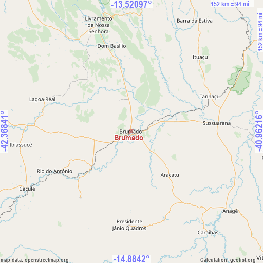
Brumado GPS coordinates[2]
14° 12' 12.996" South, 41° 39' 55.008" West
| Map corner | latitude | longitude |
|---|---|---|
| Upper-left | -13.52097°, | -42.36841° |
| Center: | -14.20361°, | -41.66528° |
| Lower-right: | -14.8842°, | -40.96216° |
| Map W x H: | 151.6×151.6 km | = 94.2×94.2mi |
| max Lat: | 2.81972° ⇑42.1% North |
| Brumado: | -14.20361° |
| min Lat: | ⇓57.9% South -33.69111° |
| min Long | Brumado | max Long |
| -72.89583° | -41.66528° | -32.41083° |
| W 67.5%⇐ | ⇒32.5% E |
Elevation
Elevation of Brumado is 427 m = 1401 ft, and this is 46.1 m = 151 ft above average elevation for this country.
| Max E: |
1603 m = 5259 ft | 44.3% |
| Brumado | 427 m 1401 ft | |
| Avg. | 380.9 m = 1250 ft | |
Min E: |
0 m = 0 ft | 55.7% |
See also: Brumado elevation on elevation.city.
Geographical zone
Brumado is located in South Torrid zone (between Equator and Tropic of Capricorn). Distance of this Southern Tropic circle is 1026.6 km =637.9 mi to South.| Distance of | km | miles | from Brumado |
|---|---|---|---|
| Equator | 1579.3 | 981.3 | to North |
| Tropic Capricorn | 1026.6 | 637.9 | to South |
| Antarctic Circle | 5821.9 | 3617.6 | to South |
| South Pole | 8427.8 | 5236.8 | to South |


Nearby cities:
15 places around Brumado: (largest is in red/bold)
• Anagé
72.9 km =45.3 mi,  128°
128°
• Barra da Estiva
73.9 km =45.9 mi,  29°
29°
• Caculé
68.6 km =42.6 mi,  240°
240°
• Caetité
88.6 km =55.1 mi,  279°
279°
• Guanambi
120.3 km =74.8 mi,  268°
268°
• Ituaçu
58.9 km =36.6 mi,  42°
42°
• Livramento do Brumado
64.4 km =40 mi,  342°
342°
• Paramirim
104.9 km =65.2 mi,  323°
323°
• Poções
144.6 km =89.9 mi,  104°
104°
• Santana
32.7 km =20.3 mi,  206°
206°
• São Felipe
76.5 km =47.5 mi,  157°
157°
• São João do Paraíso
129 km =80.2 mi,  196°
196°
• Tanhaçu
49.3 km =30.6 mi,  65°
65°
• Tremedal
90.1 km =56 mi, 162°
• Vitória da Conquista
115.4 km =71.7 mi, 129°
Sources, notices
• [Note1] Compared only with cities in Brazil existing in our database
• [Src1] Map data: © OpenStreetMap contributors (CC-BY-SA)
• [Src2] Other city data from geonames.org with taken over terms of usage.
• [Src3] Geographical zone / Annual Mean Temperature by Robert A. Rohde @ Wikipedia
