Tanhaçu geodata
Tanhaçu (Bahia) is a populated place; located in Brazil in America/Bahia (GMT-3) time zone. With population of 6,620 people, there are 1849 cities with bigger population in this country. Compared to other cities in Brazil, 58.3% of cities are located further ↓South; 69.2% of cities are located further ←West and 56.4% of cities have lower elevation than Tanhaçu. Note1


Tanhaçu GPS coordinates[2]
14° 1' 17.004" South, 41° 14' 53.016" West
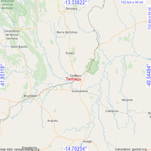
| Map corner | latitude | longitude |
|---|---|---|
| Upper-left | -13.33822°, | -41.95119° |
| Center: | -14.02139°, | -41.24806° |
| Lower-right: | -14.70254°, | -40.54494° |
| Map W x H: | 151.7×151.7 km | = 94.3×94.3mi |
| max Lat: | 2.81972° ⇑41.7% North |
| Tanhaçu: | -14.02139° |
| min Lat: | ⇓58.3% South -33.69111° |
| min Long | Tanhaçu | max Long |
| -72.89583° | -41.24806° | -32.41083° |
| W 69.2%⇐ | ⇒30.8% E |
Elevation
Elevation of Tanhaçu is 433 m = 1421 ft, and this is 52.1 m = 171 ft above average elevation for this country.
| Max E: |
1603 m = 5259 ft | 43.6% |
| Tanhaçu | 433 m 1421 ft | |
| Avg. | 380.9 m = 1250 ft | |
Min E: |
0 m = 0 ft | 56.4% |
See also: Brazil elevation on elevation.city.
Geographical zone
Tanhaçu is located in South Torrid zone (between Equator and Tropic of Capricorn). Distance of this Southern Tropic circle is 1046.9 km =650.5 mi to South.| Distance of | km | miles | from Tanhaçu |
|---|---|---|---|
| Equator | 1559 | 968.7 | to North |
| Tropic Capricorn | 1046.9 | 650.5 | to South |
| Antarctic Circle | 5842.1 | 3630.1 | to South |
| South Pole | 8448 | 5249.3 | to South |


Nearby cities:
15 places around Tanhaçu: (largest is in red/bold)
• Anagé
66.8 km =41.5 mi,  169°
169°
• Barra da Estiva
44.8 km =27.8 mi,  349°
349°
• Brumado
49.3 km =30.6 mi,  245°
245°
• Caculé
117.9 km =73.3 mi,  242°
242°
• Itiruçu
130.5 km =81.1 mi,  65°
65°
• Ituaçu
23.7 km =14.7 mi, 347°
• Jequié
126.8 km =78.8 mi,  81°
81°
• Livramento do Brumado
76.5 km =47.5 mi,  302°
302°
• Maracás
109.3 km =67.9 mi,  53°
53°
• Paramirim
124.9 km =77.6 mi, 301°
• Poções
110.6 km =68.7 mi,  120°
120°
• Santana
77.4 km =48.1 mi,  230°
230°
• São Felipe
92.2 km =57.3 mi,  189°
189°
• Tremedal
107.6 km =66.9 mi, 189°
• Vitória da Conquista
103.7 km =64.4 mi,  154°
154°
Sources, notices
• [Note1] Compared only with cities in Brazil existing in our database
• [Src1] Map data: © OpenStreetMap contributors (CC-BY-SA)
• [Src2] Other city data from geonames.org with taken over terms of usage.
• [Src3] Geographical zone / Annual Mean Temperature by Robert A. Rohde @ Wikipedia
