Guanambi geodata
Guanambi (Bahia) is a populated place; located in Brazil in America/Bahia (GMT-3) time zone. With population of 58,877 people, there are 376 cities with bigger population in this country. Compared to other cities in Brazil, 57.8% of cities are located further ↓South; 61.8% of cities are located further ←West and 65.9% of cities have lower elevation than Guanambi. Note1


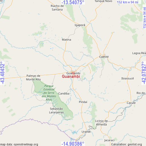
Guanambi GPS coordinates[2]
14° 13' 23.988" South, 42° 46' 53.004" West
| Map corner | latitude | longitude |
|---|---|---|
| Upper-left | -13.54075°, | -43.48452° |
| Center: | -14.22333°, | -42.78139° |
| Lower-right: | -14.90386°, | -42.07827° |
| Map W x H: | 151.6×151.6 km | = 94.2×94.2mi |
| max Lat: | 2.81972° ⇑42.2% North |
| Guanambi: | -14.22333° |
| min Lat: | ⇓57.8% South -33.69111° |
| min Long | Guanambi | max Long |
| -72.89583° | -42.78139° | -32.41083° |
| W 61.8%⇐ | ⇒38.2% E |
Elevation
Elevation of Guanambi is 531 m = 1742 ft, and this is 150.1 m = 492 ft above average elevation for this country.
| Max E: |
1603 m = 5259 ft | 34.1% |
| Guanambi | 531 m 1742 ft | |
| Avg. | 380.9 m = 1250 ft | |
Min E: |
0 m = 0 ft | 65.9% |
See also: Guanambi elevation on elevation.city.
Geographical zone
Guanambi is located in South Torrid zone (between Equator and Tropic of Capricorn). Distance of this Southern Tropic circle is 1024.4 km =636.5 mi to South.| Distance of | km | miles | from Guanambi |
|---|---|---|---|
| Equator | 1581.5 | 982.7 | to North |
| Tropic Capricorn | 1024.4 | 636.5 | to South |
| Antarctic Circle | 5819.7 | 3616.2 | to South |
| South Pole | 8425.6 | 5235.4 | to South |


Nearby cities:
15 places around Guanambi: (largest is in red/bold)
• Bom Jesus da Lapa
127.8 km =79.4 mi,  327°
327°
• Brumado
120.3 km =74.8 mi,  88°
88°
• Caculé
67.8 km =42.1 mi,  117°
117°
• Caetité
37.2 km =23.1 mi,  62°
62°
• Carinhanha
106.4 km =66.1 mi,  265°
265°
• Espinosa
78.2 km =48.6 mi,  182°
182°
• Livramento do Brumado
119.3 km =74.1 mi, 57°
• Macaúbas
134.2 km =83.4 mi,  3°
3°
• Manga
137.3 km =85.3 mi,  244°
244°
• Mato Verde
130.8 km =81.3 mi, 184°
• Monte Azul
104.1 km =64.7 mi,  185°
185°
• Palmas de Monte Alto
41.3 km =25.7 mi,  263°
263°
• Paramirim
104.7 km =65.1 mi,  34°
34°
• Riacho de Santana
70.4 km =43.7 mi,  346°
346°
• Santana
109.1 km =67.8 mi,  104°
104°
Sources, notices
• [Note1] Compared only with cities in Brazil existing in our database
• [Src1] Map data: © OpenStreetMap contributors (CC-BY-SA)
• [Src2] Other city data from geonames.org with taken over terms of usage.
• [Src3] Geographical zone / Annual Mean Temperature by Robert A. Rohde @ Wikipedia
