Guararapes geodata
Guararapes (São Paulo) is a populated place; located in Brazil in America/Sao_Paulo (GMT-3) time zone. With population of 27,557 people, there are 718 cities with bigger population in this country. Compared to other cities in Brazil, 65.1% of cities are located further ↑North; 81.1% of cities are located further →East and 54.4% of cities have lower elevation than Guararapes. Note1


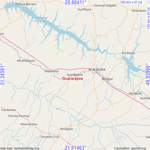
Guararapes GPS coordinates[2]
21° 15' 38.988" South, 50° 38' 34.008" West
| Map corner | latitude | longitude |
|---|---|---|
| Upper-left | -20.60411°, | -51.34591° |
| Center: | -21.26083°, | -50.64278° |
| Lower-right: | -21.91463°, | -49.93966° |
| Map W x H: | 145.7×145.7 km | = 90.5×90.5mi |
| max Lat: | 2.81972° ⇑65.1% North |
| Guararapes: | -21.26083° |
| min Lat: | ⇓34.9% South -33.69111° |
| min Long | Guararapes | max Long |
| -72.89583° | -50.64278° | -32.41083° |
| W 18.9%⇐ | ⇒81.1% E |
Elevation
Elevation of Guararapes is 413 m = 1355 ft, and this is 32.1 m = 105 ft above average elevation for this country.
| Max E: |
1603 m = 5259 ft | 45.6% |
| Guararapes | 413 m 1355 ft | |
| Avg. | 380.9 m = 1250 ft | |
Min E: |
0 m = 0 ft | 54.4% |
See also: Brazil elevation on elevation.city.
Geographical zone
Guararapes is located in South Torrid zone (between Equator and Tropic of Capricorn). Distance of this Southern Tropic circle is 241.9 km =150.3 mi to South.| Distance of | km | miles | from Guararapes |
|---|---|---|---|
| Equator | 2364 | 1468.9 | to North |
| Tropic Capricorn | 241.9 | 150.3 | to South |
| Antarctic Circle | 5037.2 | 3130 | to South |
| South Pole | 7643.1 | 4749.2 | to South |


Nearby cities:
15 places around Guararapes: (largest is in red/bold)
• Adamantina
64.8 km =40.3 mi,  223°
223°
• Araçatuba
22.5 km =14 mi,  75°
75°
• Auriflama
64.6 km =40.1 mi,  8°
8°
• Bastos
74.1 km =46 mi,  187°
187°
• Birigui
31.5 km =19.6 mi,  95°
95°
• Buritama
55.8 km =34.7 mi,  67°
67°
• General Salgado
74.1 km =46 mi,  23°
23°
• Lucélia
64.2 km =39.9 mi, 217°
• Mirandopólis
49.6 km =30.8 mi,  286°
286°
• Osvaldo Cruz
64.4 km =40 mi,  202°
202°
• Pacaembu
72.2 km =44.9 mi,  242°
242°
• Paulista Flórida
68.9 km =42.8 mi, 236°
• Penápolis
61.2 km =38 mi,  106°
106°
• Tupã
76.1 km =47.3 mi,  169°
169°
• Valparaíso
23.7 km =14.7 mi,  278°
278°
Sources, notices
• [Note1] Compared only with cities in Brazil existing in our database
• [Src1] Map data: © OpenStreetMap contributors (CC-BY-SA)
• [Src2] Other city data from geonames.org with taken over terms of usage.
• [Src3] Geographical zone / Annual Mean Temperature by Robert A. Rohde @ Wikipedia
