Nova Venécia geodata
Nova Venécia (Espírito Santo) is a populated place; located in Brazil in America/Sao_Paulo (GMT-3) time zone. With population of 28,362 people, there are 697 cities with bigger population in this country. Compared to other cities in Brazil, 52.4% of cities are located further ↑North; 73.1% of cities are located further ←West and 74.6% of cities have higher elevation than Nova Venécia. Note1


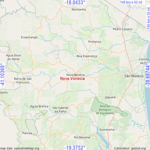
Nova Venécia GPS coordinates[2]
18° 42' 38.016" South, 40° 24' 2.016" West
| Map corner | latitude | longitude |
|---|---|---|
| Upper-left | -18.0433°, | -41.10369° |
| Center: | -18.71056°, | -40.40056° |
| Lower-right: | -19.3752°, | -39.69744° |
| Map W x H: | 148.1×148.1 km | = 92×92mi |
| max Lat: | 2.81972° ⇑52.4% North |
| Nova Venécia: | -18.71056° |
| min Lat: | ⇓47.6% South -33.69111° |
| min Long | Nova Venécia | max Long |
| -72.89583° | -40.40056° | -32.41083° |
| W 73.1%⇐ | ⇒26.9% E |
Elevation
Elevation of Nova Venécia is 80 m = 262 ft, and this is 300.9 m = 987 ft below average elevation for this country.
| Max E: |
1603 m = 5259 ft | 74.6% |
| Avg. | 380.9 m = 1250 ft | |
| Nova Venécia | 80 m = 262 ft | |
Min E: |
0 m = 0 ft | 25.4% |
See also: Brazil elevation on elevation.city.
Geographical zone
Nova Venécia is located in South Torrid zone (between Equator and Tropic of Capricorn). Distance of this Southern Tropic circle is 525.5 km =326.5 mi to South.| Distance of | km | miles | from Nova Venécia |
|---|---|---|---|
| Equator | 2080.4 | 1292.7 | to North |
| Tropic Capricorn | 525.5 | 326.5 | to South |
| Antarctic Circle | 5320.8 | 3306.2 | to South |
| South Pole | 7926.6 | 4925.4 | to South |


Nearby cities:
15 places around Nova Venécia: (largest is in red/bold)
• Barra de São Francisco
51.9 km =32.2 mi,  264°
264°
• Boa Esperança
21.9 km =13.6 mi,  30°
30°
• Colatina
95.3 km =59.2 mi,  194°
194°
• Conceição da Barra
71.6 km =44.5 mi,  79°
79°
• Ecoporanga
58.8 km =36.5 mi,  309°
309°
• Linhares
83.2 km =51.7 mi,  155°
155°
• Mantenópolis
77.9 km =48.4 mi, 257°
• Marilândia
79.5 km =49.4 mi, 190°
• Montanha
65 km =40.4 mi,  3°
3°
• Mucurici
69.7 km =43.3 mi,  349°
349°
• Nanuque
97 km =60.3 mi, 2°
• Pancas
74.3 km =46.2 mi,  219°
219°
• Rio Bananal
62.1 km =38.6 mi,  173°
173°
• São Mateus
57.1 km =35.5 mi,  91°
91°
• Águia Branca
46.9 km =29.1 mi,  229°
229°
Sources, notices
• [Note1] Compared only with cities in Brazil existing in our database
• [Src1] Map data: © OpenStreetMap contributors (CC-BY-SA)
• [Src2] Other city data from geonames.org with taken over terms of usage.
• [Src3] Geographical zone / Annual Mean Temperature by Robert A. Rohde @ Wikipedia
