Nanuque geodata
Nanuque (Minas Gerais) is a populated place; located in Brazil in America/Sao_Paulo (GMT-3) time zone. With population of 37,824 people, there are 550 cities with bigger population in this country. Compared to other cities in Brazil, 50.7% of cities are located further ↑North; 73.5% of cities are located further ←West and 71.7% of cities have higher elevation than Nanuque. Note1


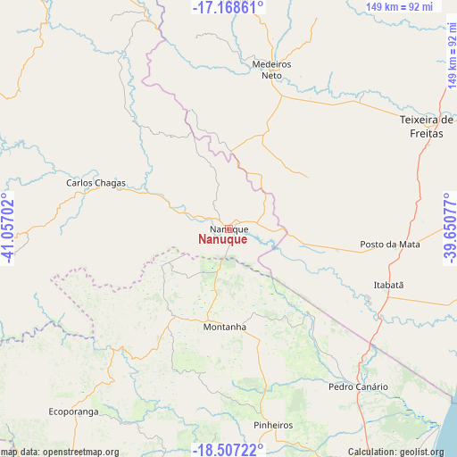
Nanuque GPS coordinates[2]
17° 50' 21.012" South, 40° 21' 14.004" West
| Map corner | latitude | longitude |
|---|---|---|
| Upper-left | -17.16861°, | -41.05702° |
| Center: | -17.83917°, | -40.35389° |
| Lower-right: | -18.50722°, | -39.65077° |
| Map W x H: | 148.8×148.8 km | = 92.5×92.5mi |
| max Lat: | 2.81972° ⇑50.7% North |
| Nanuque: | -17.83917° |
| min Lat: | ⇓49.3% South -33.69111° |
| min Long | Nanuque | max Long |
| -72.89583° | -40.35389° | -32.41083° |
| W 73.5%⇐ | ⇒26.5% E |
Elevation
Elevation of Nanuque is 108 m = 354 ft, and this is 272.9 m = 895 ft below average elevation for this country.
| Max E: |
1603 m = 5259 ft | 71.7% |
| Avg. | 380.9 m = 1250 ft | |
| Nanuque | 108 m = 354 ft | |
Min E: |
0 m = 0 ft | 28.3% |
See also: Brazil elevation on elevation.city.
Geographical zone
Nanuque is located in South Torrid zone (between Equator and Tropic of Capricorn). Distance of this Southern Tropic circle is 622.4 km =386.7 mi to South.| Distance of | km | miles | from Nanuque |
|---|---|---|---|
| Equator | 1983.5 | 1232.5 | to North |
| Tropic Capricorn | 622.4 | 386.7 | to South |
| Antarctic Circle | 5417.6 | 3366.3 | to South |
| South Pole | 8023.5 | 4985.6 | to South |


Nearby cities:
15 places around Nanuque: (largest is in red/bold)
• Boa Esperança
78.2 km =48.6 mi,  175°
175°
• Carlos Chagas
46.2 km =28.7 mi,  289°
289°
• Conceição da Barra
106.5 km =66.2 mi,  141°
141°
• Ecoporanga
77.9 km =48.4 mi,  220°
220°
• Itanhém
74.8 km =46.5 mi,  1°
1°
• Medeiros Neto
53.6 km =33.3 mi,  15°
15°
• Montanha
32 km =19.9 mi, 181°
• Mucuri
89.3 km =55.5 mi,  107°
107°
• Mucurici
33 km =20.5 mi,  211°
211°
• Nova Venécia
97 km =60.3 mi, 182°
• Nova Viçosa
104.1 km =64.7 mi,  93°
93°
• Posto da Mata
53 km =32.9 mi,  95°
95°
• São Mateus
111 km =69 mi,  151°
151°
• Teixeira de Freitas
73.1 km =45.4 mi,  62°
62°
• Águas Formosas
104.4 km =64.9 mi,  323°
323°
Sources, notices
• [Note1] Compared only with cities in Brazil existing in our database
• [Src1] Map data: © OpenStreetMap contributors (CC-BY-SA)
• [Src2] Other city data from geonames.org with taken over terms of usage.
• [Src3] Geographical zone / Annual Mean Temperature by Robert A. Rohde @ Wikipedia
