Montanha geodata
Montanha (Espírito Santo) is a populated place; located in Brazil in America/Sao_Paulo (GMT-3) time zone. With population of 11,934 people, there are 1481 cities with bigger population in this country. Compared to other cities in Brazil, 51.3% of cities are located further ↑North; 73.4% of cities are located further ←West and 62.2% of cities have higher elevation than Montanha. Note1


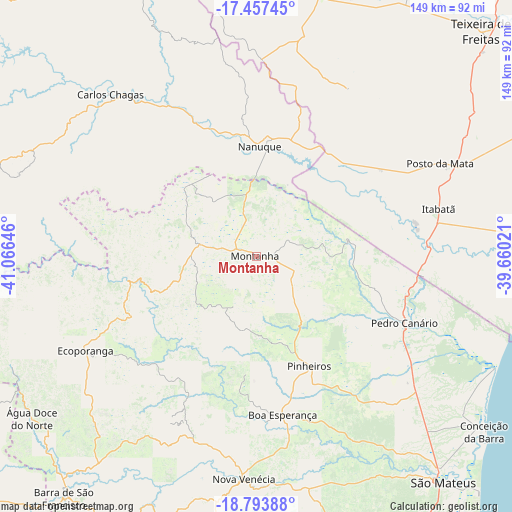
Montanha GPS coordinates[2]
18° 7' 36.984" South, 40° 21' 47.988" West
| Map corner | latitude | longitude |
|---|---|---|
| Upper-left | -17.45745°, | -41.06646° |
| Center: | -18.12694°, | -40.36333° |
| Lower-right: | -18.79388°, | -39.66021° |
| Map W x H: | 148.6×148.6 km | = 92.3×92.3mi |
| max Lat: | 2.81972° ⇑51.3% North |
| Montanha: | -18.12694° |
| min Lat: | ⇓48.7% South -33.69111° |
| min Long | Montanha | max Long |
| -72.89583° | -40.36333° | -32.41083° |
| W 73.4%⇐ | ⇒26.6% E |
Elevation
Elevation of Montanha is 191 m = 627 ft, and this is 189.9 m = 623 ft below average elevation for this country.
| Max E: |
1603 m = 5259 ft | 62.2% |
| Avg. | 380.9 m = 1250 ft | |
| Montanha | 191 m = 627 ft | |
Min E: |
0 m = 0 ft | 37.8% |
See also: Brazil elevation on elevation.city.
Geographical zone
Montanha is located in South Torrid zone (between Equator and Tropic of Capricorn). Distance of this Southern Tropic circle is 590.4 km =366.9 mi to South.| Distance of | km | miles | from Montanha |
|---|---|---|---|
| Equator | 2015.5 | 1252.4 | to North |
| Tropic Capricorn | 590.4 | 366.9 | to South |
| Antarctic Circle | 5385.6 | 3346.5 | to South |
| South Pole | 7991.5 | 4965.7 | to South |


Nearby cities:
15 places around Montanha: (largest is in red/bold)
• Barra de São Francisco
89.3 km =55.5 mi,  218°
218°
• Boa Esperança
46.5 km =28.9 mi,  171°
171°
• Carlos Chagas
63.6 km =39.5 mi,  317°
317°
• Conceição da Barra
84.4 km =52.4 mi,  127°
127°
• Ecoporanga
56.4 km =35 mi,  240°
240°
• Itanhém
106.9 km =66.4 mi,  1°
1°
• Medeiros Neto
85.1 km =52.9 mi,  10°
10°
• Mucuri
86 km =53.4 mi,  86°
86°
• Mucurici
16.5 km =10.3 mi,  283°
283°
• Nanuque
32 km =19.9 mi, 1°
• Nova Venécia
65 km =40.4 mi,  183°
183°
• Posto da Mata
59.9 km =37.2 mi,  63°
63°
• São Mateus
84.7 km =52.6 mi,  141°
141°
• Teixeira de Freitas
93 km =57.8 mi,  44°
44°
• Águia Branca
103.2 km =64.1 mi,  202°
202°
Sources, notices
• [Note1] Compared only with cities in Brazil existing in our database
• [Src1] Map data: © OpenStreetMap contributors (CC-BY-SA)
• [Src2] Other city data from geonames.org with taken over terms of usage.
• [Src3] Geographical zone / Annual Mean Temperature by Robert A. Rohde @ Wikipedia
