Taperoá geodata
Taperoá (Bahia) is a populated place; located in Brazil in America/Bahia (GMT-3) time zone. With population of 8,095 people, there are 1767 cities with bigger population in this country. Compared to other cities in Brazil, 58.9% of cities are located further ↓South; 79.6% of cities are located further ←West and 98.3% of cities have higher elevation than Taperoá. Note1


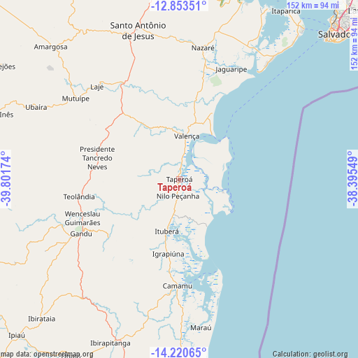
Taperoá GPS coordinates[2]
13° 32' 17.016" South, 39° 5' 54.996" West
| Map corner | latitude | longitude |
|---|---|---|
| Upper-left | -12.85351°, | -39.80174° |
| Center: | -13.53806°, | -39.09861° |
| Lower-right: | -14.22065°, | -38.39549° |
| Map W x H: | 152×152 km | = 94.4×94.4mi |
| max Lat: | 2.81972° ⇑41.1% North |
| Taperoá: | -13.53806° |
| min Lat: | ⇓58.9% South -33.69111° |
| min Long | Taperoá | max Long |
| -72.89583° | -39.09861° | -32.41083° |
| W 79.6%⇐ | ⇒20.4% E |
Elevation
Elevation of Taperoá is 6 m = 20 ft, and this is 374.9 m = 1230 ft below average elevation for this country.
| Max E: |
1603 m = 5259 ft | 98.3% |
| Avg. | 380.9 m = 1250 ft | |
| Taperoá | 6 m = 20 ft | |
Min E: |
0 m = 0 ft | 1.7% |
See also: Brazil elevation on elevation.city.
Geographical zone
Taperoá is located in South Torrid zone (between Equator and Tropic of Capricorn). Distance of this Southern Tropic circle is 1100.6 km =683.9 mi to South.| Distance of | km | miles | from Taperoá |
|---|---|---|---|
| Equator | 1505.3 | 935.3 | to North |
| Tropic Capricorn | 1100.6 | 683.9 | to South |
| Antarctic Circle | 5895.9 | 3663.5 | to South |
| South Pole | 8501.8 | 5282.8 | to South |


Nearby cities:
15 places around Taperoá: (largest is in red/bold)
• Amargosa
78.7 km =48.9 mi,  315°
315°
• Camamu
45.2 km =28.1 mi,  180°
180°
• Gandu
47.8 km =29.7 mi,  241°
241°
• Ibirapitanga
75.7 km =47 mi,  203°
203°
• Ibirataia
83 km =51.6 mi,  224°
224°
• Ituberá
22.6 km =14 mi,  193°
193°
• Maraú
63.6 km =39.5 mi,  171°
171°
• Muritiba
71 km =44.1 mi,  346°
346°
• Mutuípe
55.8 km =34.7 mi,  308°
308°
• Nazaré
56.7 km =35.2 mi,  9°
9°
• Santa Inês
82.6 km =51.3 mi,  289°
289°
• Santo Antônio de Jesus
65.7 km =40.8 mi,  344°
344°
• Sobradinho
78.4 km =48.7 mi,  359°
359°
• Ubaíra
68 km =42.3 mi,  296°
296°
• Valença
18.9 km =11.7 mi, 8°
Sources, notices
• [Note1] Compared only with cities in Brazil existing in our database
• [Src1] Map data: © OpenStreetMap contributors (CC-BY-SA)
• [Src2] Other city data from geonames.org with taken over terms of usage.
• [Src3] Geographical zone / Annual Mean Temperature by Robert A. Rohde @ Wikipedia
