Valença geodata
Valença (Bahia) is a populated place; located in Brazil in America/Bahia (GMT-3) time zone. With population of 63,231 people, there are 355 cities with bigger population in this country. Compared to other cities in Brazil, 59.3% of cities are located further ↓South; 79.7% of cities are located further ←West and 95.4% of cities have higher elevation than Valença. Note1


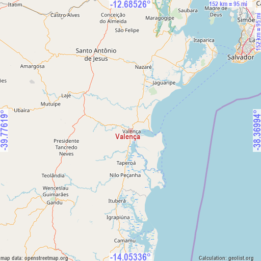
Valença GPS coordinates[2]
13° 22' 13.008" South, 39° 4' 23.016" West
| Map corner | latitude | longitude |
|---|---|---|
| Upper-left | -12.68526°, | -39.77619° |
| Center: | -13.37028°, | -39.07306° |
| Lower-right: | -14.05336°, | -38.36994° |
| Map W x H: | 152.1×152.1 km | = 94.5×94.5mi |
| max Lat: | 2.81972° ⇑40.7% North |
| Valença: | -13.37028° |
| min Lat: | ⇓59.3% South -33.69111° |
| min Long | Valença | max Long |
| -72.89583° | -39.07306° | -32.41083° |
| W 79.7%⇐ | ⇒20.3% E |
Elevation
Elevation of Valença is 9 m = 30 ft, and this is 371.9 m = 1220 ft below average elevation for this country.
| Max E: |
1603 m = 5259 ft | 95.4% |
| Avg. | 380.9 m = 1250 ft | |
| Valença | 9 m = 30 ft | |
Min E: |
0 m = 0 ft | 4.6% |
See also: Valença elevation on elevation.city.
Geographical zone
Valença is located in South Torrid zone (between Equator and Tropic of Capricorn). Distance of this Southern Tropic circle is 1119.3 km =695.5 mi to South.| Distance of | km | miles | from Valença |
|---|---|---|---|
| Equator | 1486.6 | 923.7 | to North |
| Tropic Capricorn | 1119.3 | 695.5 | to South |
| Antarctic Circle | 5914.5 | 3675.1 | to South |
| South Pole | 8520.4 | 5294.3 | to South |


Nearby cities:
15 places around Valença: (largest is in red/bold)
• Amargosa
68.9 km =42.8 mi,  303°
303°
• Camamu
64 km =39.8 mi,  182°
182°
• Conceição do Almeida
66.5 km =41.3 mi,  350°
350°
• Gandu
61 km =37.9 mi,  227°
227°
• Itaparica
68.5 km =42.6 mi,  38°
38°
• Ituberá
41.4 km =25.7 mi,  191°
191°
• Maragogipe
67.9 km =42.2 mi,  14°
14°
• Muritiba
54 km =33.6 mi,  339°
339°
• Mutuípe
49.3 km =30.6 mi,  288°
288°
• Nazaré
37.8 km =23.5 mi, 9°
• Salvador
75.3 km =46.8 mi,  53°
53°
• Santo Antônio de Jesus
49.1 km =30.5 mi, 335°
• Sobradinho
59.8 km =37.2 mi,  357°
357°
• Taperoá
18.9 km =11.7 mi, 188°
• Ubaíra
64.8 km =40.3 mi,  280°
280°
Sources, notices
• [Note1] Compared only with cities in Brazil existing in our database
• [Src1] Map data: © OpenStreetMap contributors (CC-BY-SA)
• [Src2] Other city data from geonames.org with taken over terms of usage.
• [Src3] Geographical zone / Annual Mean Temperature by Robert A. Rohde @ Wikipedia
