Iguatemi geodata
Iguatemi (Mato Grosso do Sul) is a populated place; located in Brazil in America/Campo_Grande (GMT-4) time zone. With population of 9,619 people, there are 1677 cities with bigger population in this country. Compared to other cities in Brazil, 84.3% of cities are located further ↑North; 93.4% of cities are located further →East and 51% of cities have higher elevation than Iguatemi. Note1


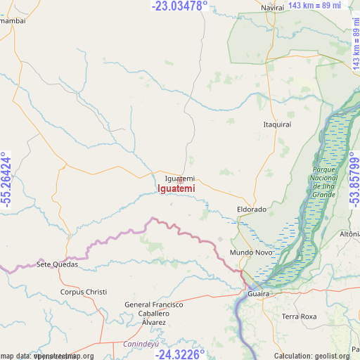
Iguatemi GPS coordinates[2]
23° 40' 49.008" South, 54° 33' 39.996" West
| Map corner | latitude | longitude |
|---|---|---|
| Upper-left | -23.03478°, | -55.26424° |
| Center: | -23.68028°, | -54.56111° |
| Lower-right: | -24.3226°, | -53.85799° |
| Map W x H: | 143.2×143.2 km | = 89×89mi |
| max Lat: | 2.81972° ⇑84.3% North |
| Iguatemi: | -23.68028° |
| min Lat: | ⇓15.7% South -33.69111° |
| min Long | Iguatemi | max Long |
| -72.89583° | -54.56111° | -32.41083° |
| W 6.6%⇐ | ⇒93.4% E |
Elevation
Elevation of Iguatemi is 342 m = 1122 ft, and this is 38.9 m = 128 ft below average elevation for this country.
| Max E: |
1603 m = 5259 ft | 51% |
| Avg. | 380.9 m = 1250 ft | |
| Iguatemi | 342 m = 1122 ft | |
Min E: |
0 m = 0 ft | 49% |
See also: Brazil elevation on elevation.city.
Geographical zone
Iguatemi is located in South temperate zone (between Tropic of Capricorn and the Antarctic Circle). Distance of this Southern Tropic circle is 27.1 km =16.8 mi to North.| Distance of | km | miles | from Iguatemi |
|---|---|---|---|
| Equator | 2633 | 1636.1 | to North |
| Tropic Capricorn | 27.1 | 16.8 | to North |
| Antarctic Circle | 4768.2 | 2962.8 | to South |
| South Pole | 7374.1 | 4582.1 | to South |


Nearby cities:
15 places around Iguatemi: (largest is in red/bold)
• Alto Piquiri
120.3 km =74.8 mi,  108°
108°
• Altãnia
70.5 km =43.8 mi, 107°
• Caarapó
119.3 km =74.1 mi,  347°
347°
• Costa Rica
30.7 km =19.1 mi,  342°
342°
• Cruzeiro do Oeste
151.9 km =94.4 mi,  94°
94°
• Eldorado
30.6 km =19 mi, 112°
• Iporã
94.3 km =58.6 mi, 112°
• Marechal Cândido Rondon
110 km =68.4 mi,  152°
152°
• Moreira Sales
163.6 km =101.7 mi, 105°
• Naviraí
78.2 km =48.6 mi,  28°
28°
• Palotina
99.4 km =61.8 mi,  132°
132°
• Paranhos
91.6 km =56.9 mi,  255°
255°
• Pôrto Barra do Ivinheima
121 km =75.2 mi,  49°
49°
• Toledo
141.7 km =88 mi,  144°
144°
• Umuarama
126.2 km =78.4 mi, 94°
Sources, notices
• [Note1] Compared only with cities in Brazil existing in our database
• [Src1] Map data: © OpenStreetMap contributors (CC-BY-SA)
• [Src2] Other city data from geonames.org with taken over terms of usage.
• [Src3] Geographical zone / Annual Mean Temperature by Robert A. Rohde @ Wikipedia
