Araçuaí geodata
Araçuaí (Minas Gerais) is a populated place; located in Brazil in America/Sao_Paulo (GMT-3) time zone. With population of 22,005 people, there are 869 cities with bigger population in this country. Compared to other cities in Brazil, 51.2% of cities are located further ↓South; 65.6% of cities are located further ←West and 52.4% of cities have higher elevation than Araçuaí. Note1


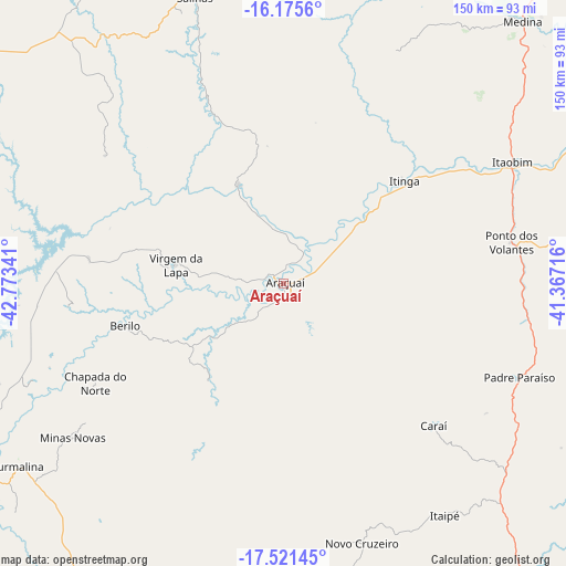
Araçuaí GPS coordinates[2]
16° 50' 58.992" South, 42° 4' 13.008" West
| Map corner | latitude | longitude |
|---|---|---|
| Upper-left | -16.1756°, | -42.77341° |
| Center: | -16.84972°, | -42.07028° |
| Lower-right: | -17.52145°, | -41.36716° |
| Map W x H: | 149.6×149.6 km | = 93×93mi |
| max Lat: | 2.81972° ⇑48.8% North |
| Araçuaí: | -16.84972° |
| min Lat: | ⇓51.2% South -33.69111° |
| min Long | Araçuaí | max Long |
| -72.89583° | -42.07028° | -32.41083° |
| W 65.6%⇐ | ⇒34.4% E |
Elevation
Elevation of Araçuaí is 316 m = 1037 ft, and this is 64.9 m = 213 ft below average elevation for this country.
| Max E: |
1603 m = 5259 ft | 52.4% |
| Avg. | 380.9 m = 1250 ft | |
| Araçuaí | 316 m = 1037 ft | |
Min E: |
0 m = 0 ft | 47.6% |
See also: Brazil elevation on elevation.city.
Geographical zone
Araçuaí is located in South Torrid zone (between Equator and Tropic of Capricorn). Distance of this Southern Tropic circle is 732.4 km =455.1 mi to South.| Distance of | km | miles | from Araçuaí |
|---|---|---|---|
| Equator | 1873.5 | 1164.1 | to North |
| Tropic Capricorn | 732.4 | 455.1 | to South |
| Antarctic Circle | 5527.7 | 3434.8 | to South |
| South Pole | 8133.5 | 5053.9 | to South |


Nearby cities:
15 places around Araçuaí: (largest is in red/bold)
• Capelinha
104.9 km =65.2 mi,  206°
206°
• Caraí
54.9 km =34.1 mi,  133°
133°
• Itinga
41.8 km =26 mi,  50°
50°
• Jequitinhonha
122.7 km =76.2 mi,  67°
67°
• Joaíma
112.8 km =70.1 mi,  78°
78°
• Malacacheta
110.4 km =68.6 mi,  180°
180°
• Medina
94.1 km =58.5 mi,  42°
42°
• Minas Novas
68.8 km =42.8 mi,  233°
233°
• Novo Cruzeiro
71.8 km =44.6 mi,  163°
163°
• Padre Paraíso
67.1 km =41.7 mi,  111°
111°
• Pedra Azul
125 km =77.7 mi, 41°
• Salinas
79.1 km =49.2 mi,  342°
342°
• Taiobeiras
117.1 km =72.8 mi,  351°
351°
• Turmalina
85.2 km =52.9 mi,  235°
235°
• Águas Formosas
123.4 km =76.7 mi,  102°
102°
Sources, notices
• [Note1] Compared only with cities in Brazil existing in our database
• [Src1] Map data: © OpenStreetMap contributors (CC-BY-SA)
• [Src2] Other city data from geonames.org with taken over terms of usage.
• [Src3] Geographical zone / Annual Mean Temperature by Robert A. Rohde @ Wikipedia
