Lucas geodata
Lucas (Mato Grosso) is a populated place; located in Brazil in America/Cuiaba (GMT-4) time zone. With population of 27,665 people, there are 714 cities with bigger population in this country. Compared to other cities in Brazil, 52.7% of cities are located further ↓South; 95.1% of cities are located further →East and 68.7% of cities have higher elevation than Lucas. Note1


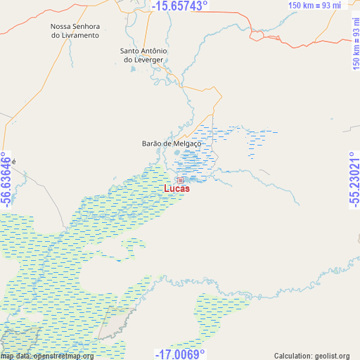
Lucas GPS coordinates[2]
16° 19' 59.988" South, 55° 55' 59.988" West
| Map corner | latitude | longitude |
|---|---|---|
| Upper-left | -15.65743°, | -56.63646° |
| Center: | -16.33333°, | -55.93333° |
| Lower-right: | -17.0069°, | -55.23021° |
| Map W x H: | 150×150 km | = 93.2×93.2mi |
| max Lat: | 2.81972° ⇑47.3% North |
| Lucas: | -16.33333° |
| min Lat: | ⇓52.7% South -33.69111° |
| min Long | Lucas | max Long |
| -72.89583° | -55.93333° | -32.41083° |
| W 4.9%⇐ | ⇒95.1% E |
Elevation
Elevation of Lucas is 134 m = 440 ft, and this is 246.9 m = 810 ft below average elevation for this country.
| Max E: |
1603 m = 5259 ft | 68.7% |
| Avg. | 380.9 m = 1250 ft | |
| Lucas | 134 m = 440 ft | |
Min E: |
0 m = 0 ft | 31.3% |
See also: Brazil elevation on elevation.city.
Geographical zone
Lucas is located in South Torrid zone (between Equator and Tropic of Capricorn). Distance of this Southern Tropic circle is 789.8 km =490.8 mi to South.| Distance of | km | miles | from Lucas |
|---|---|---|---|
| Equator | 1816.1 | 1128.5 | to North |
| Tropic Capricorn | 789.8 | 490.8 | to South |
| Antarctic Circle | 5585.1 | 3470.4 | to South |
| South Pole | 8191 | 5089.6 | to South |


Nearby cities:
15 places around Lucas: (largest is in red/bold)
• Barra do Bugres
193.6 km =120.3 mi,  316°
316°
• Barão de Melgaço
15.9 km =9.9 mi,  346°
346°
• Chapada dos Guimarães
99 km =61.5 mi,  11°
11°
• Cuiabá
83.8 km =52.1 mi, 347°
• Diamantino
221 km =137.3 mi, 345°
• Jaciara
110.9 km =68.9 mi,  68°
68°
• Nobres
184.3 km =114.5 mi, 346°
• Nortelândia
228.7 km =142.1 mi,  335°
335°
• Nova Olímpia
224.1 km =139.2 mi, 319°
• Poconé
74.1 km =46 mi,  276°
276°
• Poxoréo
173.9 km =108.1 mi, 71°
• Rondonópolis
139.3 km =86.6 mi,  96°
96°
• Rosário Oeste
174.7 km =108.6 mi, 342°
• Santo Antônio do Leverger
54.2 km =33.7 mi, 343°
• Várzea Grande
79.3 km =49.3 mi, 344°
Sources, notices
• [Note1] Compared only with cities in Brazil existing in our database
• [Src1] Map data: © OpenStreetMap contributors (CC-BY-SA)
• [Src2] Other city data from geonames.org with taken over terms of usage.
• [Src3] Geographical zone / Annual Mean Temperature by Robert A. Rohde @ Wikipedia
